After Period of Slow Melt, Arctic Ice Extent is Again Declining Rapidly - The Arctic Institute - Center for Circumpolar Security Studies
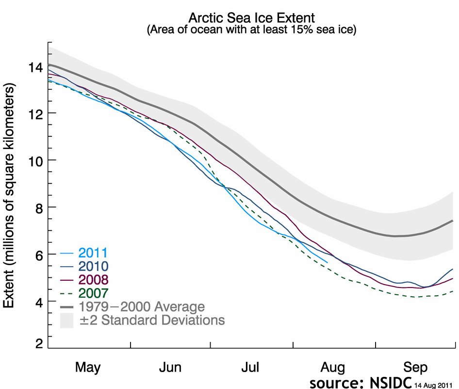
With about a month to go before the snow melt season concludes at the end of September, the Arctic ice cap has begun shrinking at a faster pace again. It now covers the second smallest area ever observed for mid-August.
Satellite imagery released by National Snow and Ice Data Center (NSIDC), showed that ice covered 5.56 million square kilometers on Aug. 14 – about 2.11 million square kilometers below the average for that date, but 220,000 square miles above the record minimum from 2007.
According to NSIDC, “Sea ice is low across almost all of the Arctic, with the exception of some areas of the East Greenland Sea. It is exceptionally low in the Laptev and Kara Sea areas.”
The Arctic ice cap plays an essential role in stabilising the world’s climate. The loss of summer-time ice directly contributes to climate change since darker open water absorbs more solar energy than white ice floes. Solar energy is stored in the ocean and thus melting continues even when the solar radiation begins to weaken in September.
Arctic sea ice is highly responsive to a shift in weather patterns. During early summer continued high-pressure across the northern Beaufort Sea accelerated ice loss. By the end of July the weather pattern had shifted and colder temperatures prevailed slowing the ice loss. At the same time, however, strong winds spread out the ice pack resulting in thinner than average ice-coverage. The renewed acceleration of melting can be attributed to the return of high-pressure in the region which results in higher temperatures.
The question if the 2011 minimum ice extent ends up being slightly above or below the record year of 2007 will depend mostly on the weather patterns over the coming two weeks.
Improved resolution of satellite imagery suggests that 2011 ice extent has been tracking closer to the 2007 record low than earlier measurements suggested. The more sophisticated system used for the latest set of data resolves ice pack down to 6.1 kilometers compared to the previous 24.9 kilometers. Hence the system can detect small but widespread areas of open water that were previously thought to be continuous ice.
New satellite images also show that the Northwest Passage now appears to be free of ice and could theoretically be navigated by ships. On the other side of the Arctic Ocean, the Northern Sea Route (NSR) has been open for shipping traffic since July. The Russian gas producer Novatek plans to send the 120,000-ton tanker Vladimir Tikhonov along the Siberian coast and through the Bering Strait. In total, Novatek plans to ship more than 400,000 tons of gas condensate along the NSR in 2011.
Meanwhile, the National Oceanic and Atmospheric Administration (NOAA) reports, that average temperatures across the globe for the month of July was 61.4 Fahrenheit (16.4 Celsius), about 1 degree Fahrenheit over the 20th century July average. That’s the seventh-warmest July since records started being kept in 1880.
July 2011 was the 317th consecutive month with a positive global temperature anomaly. The last month to have a global temperature below its 20th century average was February 1985.