The Intersection of U.S. Military Infrastructure & Alaskan Permafrost Through the 21st Century
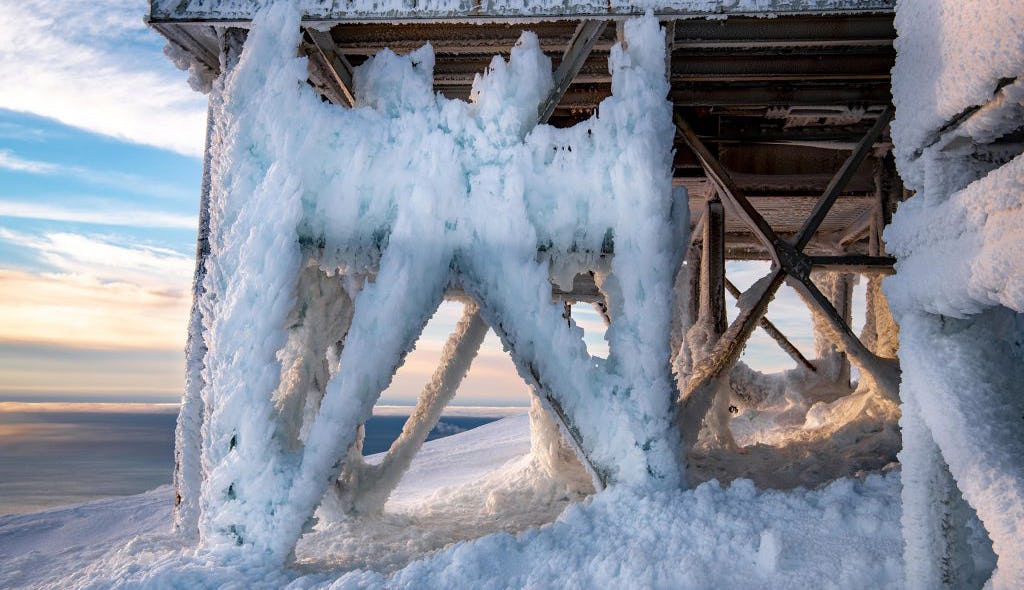
Long Range Radar Site Scanning Airspace for Threats Upon a Thawing Foundation in Tin City, Alaska. Photo: Senior Chief Petty Officer Brandon Raile
Permafrost thaw is one of the world’s most pressing climate problems, already disrupting lifestyles, livelihoods, economies, and ecosystems in the north, and threatening to spill beyond the boundaries of the Arctic as our planet continues to warm. To examine the effects of permafrost degradation, and increase our understanding of what this phenomenon means for the future of the region (and the world), The Arctic Institute’s new two-part permafrost series aims to analyze the topic from scientific, security, legal, and personal perspectives.
The Arctic Institute Permafrost Series 2020
- Permafrost Thaw in a Warming World: The Arctic Institute’s Permafrost Series Fall-Winter 2020
- Takeaways from the Arctic Tundra
- Dwindling Arctic Sea Ice and Impacts to Permafrost Health
- Frozen-Ground Cartoons: A Multiform Innovative Project for Permafrost Science Communication and Outreach
- The Intersection of U.S. Military Infrastructure & Alaskan Permafrost Through the 21st Century
- When ‘Perma’ Is No Longer ‘Perma’: Investigating Permafrost Degradation in Churchill, Manitoba
- A Blessing and a Curse: Melting Permafrost in the Russian Arctic
- Carbon: Three Observations on Life, Death, and Uncertainty in the Permafrost
- Translating Newfound Permafrost Knowledge into Climate Action
As centuries-worth of subterraneous ice-infused permafrost quakes, cracks, and is crippled by continuous creep and vertical crush, it can no longer bear the load it has shouldered and upheld for millennia. Its life cycle has come to an end; the permafrost thaws into a state of slush. This drastic change is becoming a near-ubiquitous development of the Arctic Circle, one with which human populations and their leaders are struggling to contend.
In order to better understand how permafrost will affect the Alaskan landscape and U.S. security infrastructure, I consulted climate modeling exercises driven under a variety of scenarios. In this article, I will analyze the modeling exercises and the state of Arctic security infrastructure, and provide recommendations for the U.S. military that will help prepare Alaskan military bases and the U.S. North Warning System for permafrost thaw in the 21st century.
Aging U.S. Arctic Security Infrastructure
Purchased in 1867 by President Andrew Johnson, Alaska has proven to be a strategic investment. At the time, U.S. citizens were baffled by the newly-admitted territory and the frivolous use of taxpayer dollars, and dubbed the purchase “Johnson’s Polar Bear Garden.”1) Although purchasing the landmass was not a popular decision at the time, Alaska became a pulpit of power projection in an increasingly bipolar and nuclear world.
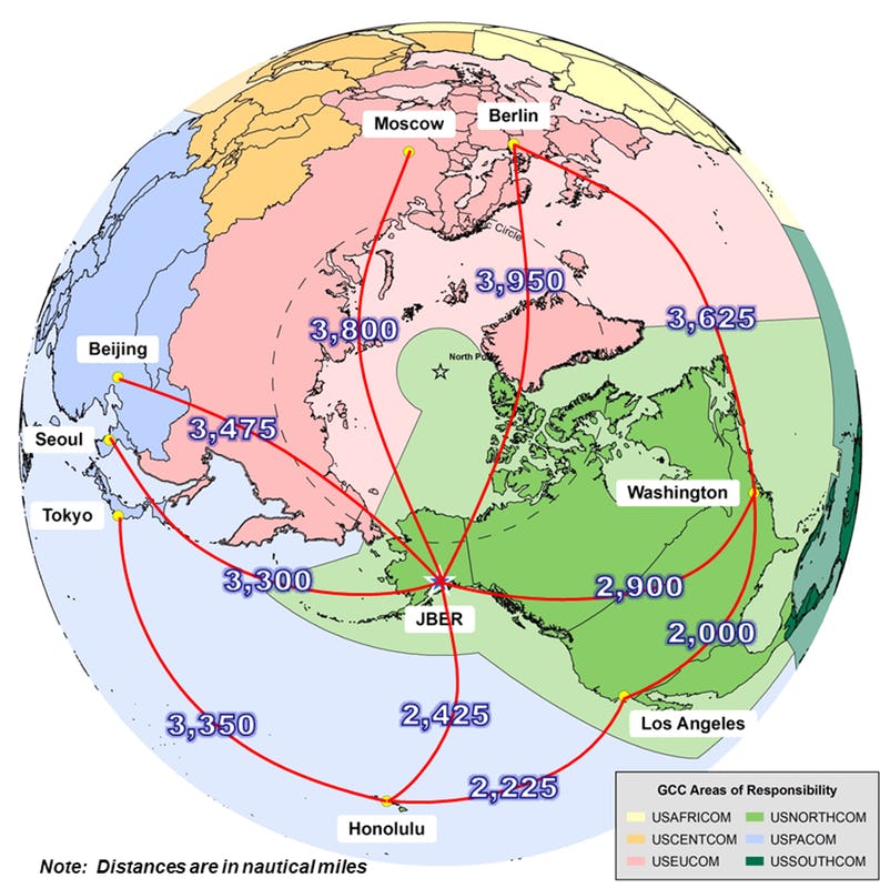
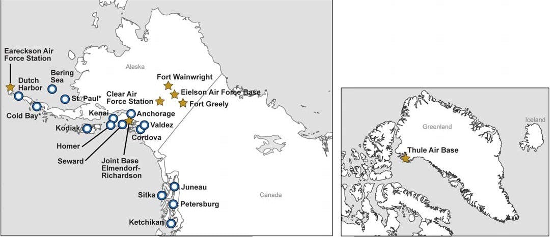
Alaska is the closest U.S. state to major Russian population centers (3,800 nautical miles between Juneau, AK and Moscow, Russia), making it a geostrategic location for U.S. security fixtures.2) Security infrastructure in Alaska is the underpinning of northern missile detection and defense. Arctic airspace was monitored during the Cold War and continues to be monitored with the North Warning System (NWS). In Alaska alone, there are 21 radar sites that monitor, detect, and alert officials at the North American Aerospace Defense Command to the possibility of inter-continental ballistic missiles.3) While this is a critical capability, threats have evolved with new military technology. Currently, the NWS is unable to detect drones or hypersonic weapons that could traverse the Arctic.4) Updates to the NWS system are sorely needed. Unfortunately, after the decline of the Cold War, the NWS ceased to make the priority list for upgrades and suffers from technological and structural issues.5) Similarly, Alaska’s 6 military bases and 49 national guard posts are also in need of updates.
Modern U.S. Arctic Security Challenges in a Changing Climate
Permafrost thaw in Alaska is as much a vulnerability to Arctic security as outdated technology. The 2019 Department of Defense Arctic Strategy Report concluded that “[t]hawing permafrost, compounded by storm surge and coastal erosion, adversely affects infrastructure, including DOD installations, and complicates the development of new and resilient DOD infrastructure.”6)
New and resilient infrastructure is integral to U.S. military operations and include its bases, vehicles, airstrips, roads, the North Warning System, etc. Permafrost (soil at or below the freezing point of water [32°F] for two or more years)7) compromises the foundation for many of these structures. Today, permafrost is found beneath nearly 85 percent of Alaska, with higher concentrations in Northern Alaska.8) 9) Historically, engineers have relied on permafrost’s ability to remain frozen year to year. However, in the 1970s, Alaska started to experience higher temperatures and increased rates of permafrost thaw. As infrastructure began to shift, reservoirs, wastewater treatment plants, roads, buildings, etc. were disrupted by ground sink.
While climate change poses significant vulnerabilities for the North, there are many benefits as well. Warmer temperatures are increasing the amount of time U.S. personnel spend in the Arctic year-round. Simultaneously, the cost associated with operations that require mitigations against sub-freezing temperatures are decreasing. Thawing permafrost also allows stable structures to be built in permafrost-free areas.
Climate Modeling for Arctic Security Interests
To better ascertain how climate change will impact U.S. Arctic security infrastructure throughout the 21st century, the military needs to utilize and invest in climate modeling. Climate modeling helps assess how climate change will affect the Arctic landscape under a variety of conditions.10) While some climate-related changes may be detrimental to U.S. security infrastructure, there are also benefits that improve operating conditions in the Arctic. A proactive approach in the U.S. response to a changing Arctic environment will ensure the stability of military infrastructure in the region. Failure to prepare for this change could result in the U.S.’ inability to detect and defend the American people in the event of an Arctic-originating attack.
To achieve a better understanding of how permafrost thaw would impact U.S. security infrastructure, I consulted the most recent and comprehensive climate modeling exercise: The Coupled Model Inter-Comparison Project Phase 5 (CMIP-5) Modeling Exercise. CMIP-5 is a modeling exercise involving Atmosphere-Ocean General Circulation Models and Earth System Models.11) There are nearly 70 models in the exercise, which increases the knowledge base it pulls from, thus making it more robust than any other exercise before it.12) Furthermore, the necessary assumptions in these models are made with the most advanced scientific knowledge available. Therefore, the foundational knowledge in this exercise is more accurate than previous versions.13) The CMIP-5 modeling exercise is driven by Representative Concentration Pathways (RCP) scenarios.
To better understand how climate modeling and RCP scenarios interact to yield climate projections, imagine a coach preparing a school basketball team for a game. The future is uncertain, but this team’s aspiration is to win. The coach knows their strengths, weaknesses, abilities, and limitations. She organizes the players on the court in accordance with the available information. The coach makes assumptions about the other team to prepare her team. For example, the opposing team might have a slight height advantage, but a lower skill level. The coach runs through multiple plays with her team. For example, if Player A steals the ball from the offensive team, Player A will pass the ball to Player B who is further down the court. Player B can then take the shot. In this analogy, the modeling exercise is the coach’s knowledge of her team, their positioning, and assumptions about the other team. The RCP scenarios are the plays that the basketball players prepare for that may or may not happen in the upcoming game.
RCP scenarios help scientists and policymakers gauge the repercussions of various levels of greenhouse gas and radiative forcing through the end of the 21st century. There are 4 RCP scenarios that drive the CMIP-5 modeling exercise: 2.6, 4.5, 6.0, and 8.5 watts per meter squared.14) RCP 2.6 represents a low emissions scenario, wherein the global community works aggressively to reduce emissions production. RCP 4.5 and 6.0 are middle of the road estimates. RCP 8.5 represents a very high emissions scenario with no action taken by the global community to reduce emissions productions.
It is important to mention that inherent in their design, climate modeling exercises are uncertain because they cannot be compared with non-existent empirical data. However, climate projections of past conditions have been corroborated with data from ice cores, coral reefs, glaciers, weather station data, and other figures, which increases confidence in their projections. While modeling exercises may not be able precisely identify future conditions, they can help discern the following:
- Probable and improbable climate trends
- Expected climate outcomes under certain conditions
- The role human activity can play in climate forcing.
Permafrost Projections
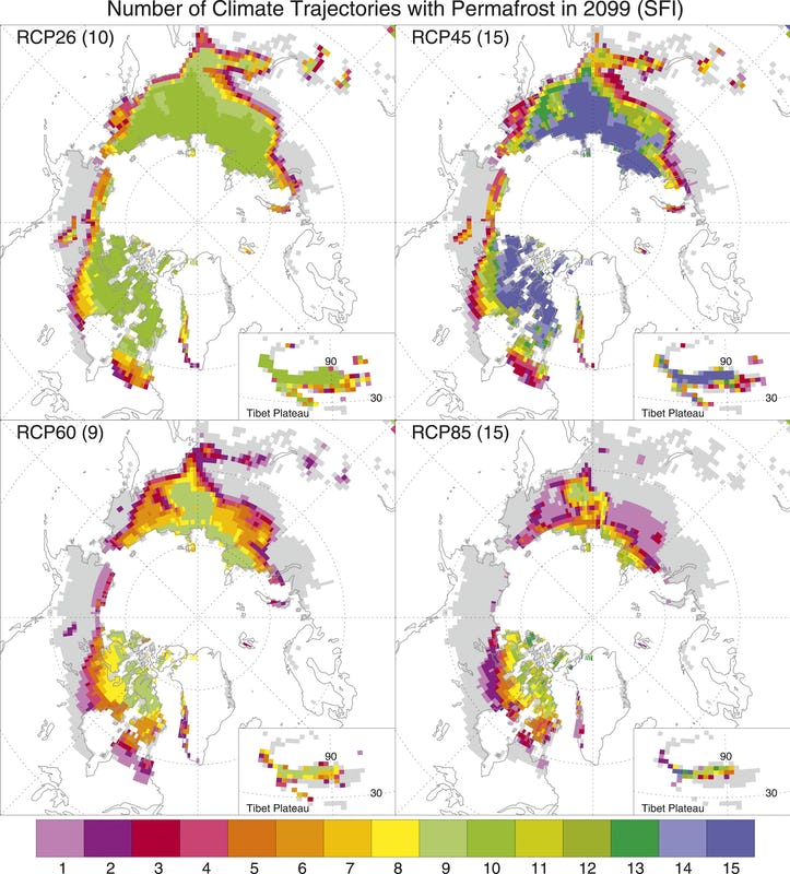
Under all RCP scenarios, permafrost coverage decreases significantly in Alaska as well as the Arctic Circle.15) Under RCP 2.6, 4.5, and 6.0, Alaska’s North Slope will experience a significant decrease in the underlying permafrost by 2100. Conversely, in RCP 8.5, Alaskan permafrost coverage decreases to the point where it would exist only in a few spots along Alaska’s Northern coast. In contrast, Russia will not see the loss of permafrost on their Northern coast even under the RCP 8.5 scenario.16) This information presents a strategic opportunity for sustained, cost-effective infrastructure construction in the event of a high-emissions scenario. Furthermore, this difference in projected permafrost coverage can be strategically applied to U.S. military interests, and will be elaborated upon further in the recommendations.
The figure below breaks down global permafrost projections by RCP scenarios under CMIP-5 on a 1980-2100 timeline. Between 2020 and 2030, differences between the RCP scenario are small. For 2020, projected (and verified) permafrost coverage ranges from 13 million km2 to 14.5 million km2, across RCPs. By 2030, the projected range is 11.2 million km2 to 13.8 million km2, across RCPs (an average difference of 1.65 million km2).
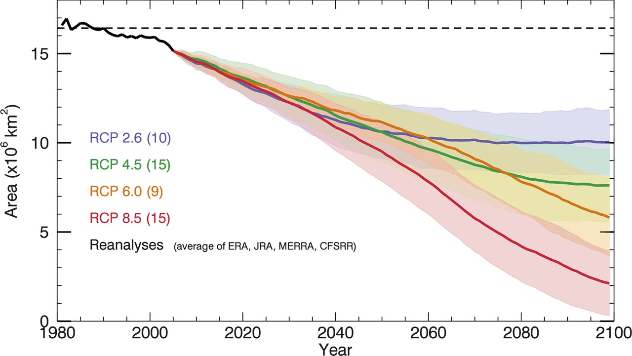
The range for 2030 to 2050 is more pronounced: for 2050 projections are 8 million km2 to 12.2 million km2, across RCPs. Compared with the 2020-2030 time period, this range of possibilities is greater (an average of 2.4 million km2).
As expected, the range of projections only grow when considering the 2050-2100 time period. In 2100, projected permafrost for RCP2.6 ranges from 9 million km2 to 12 million km2. Alternatively, RCP8.5 emissions scenario projects a range of >1 million km2 to 4 million km2 by 2100. See the figure below for a 2100 visualization of Arctic permafrost under the RCP scenarios.
While the CMIP-5 projections driven by the RCP emissions scenarios indicate a wide range in possible outcomes, global and regional trends on this timescale can be especially helpful when planning for adaptation and response to different time periods. The information gained from this climate modeling exercise (relevant to U.S. security infrastructure) is as follows:
- Permafrost coverage will continue to decrease under all scenarios which will disrupt the foundations of all U.S. security infrastructure throughout Alaska.
- Within the 21st century, absence of permafrost will present the U.S. military with increased possibilities for foundationally stable military infrastructure locations as well as lower costs of construction.
- Alaska will experience a higher rate of permafrost melt compared with Russia under all scenarios, which positions the U.S. military and its future infrastructure in more stable operating conditions than its counterpart.
Adapting to Arctic Climate Change and Technological Advances
In order to best prepare U.S. military infrastructure in Alaska there are multiple phases of development that will need to occur. I have broken these time phases into three time periods: 2020-2030, 2030-2050, and 2050-2100.
Phase 1: 2020-2030
The 2020-2030 time period presents opportunities and limitations for critical infrastructure associated with permafrost thaw. Southern Alaska will continue to experience significant permafrost thaw. Once the permafrost has thawed and maintains this state for at least two years, the U.S. military will be able to make sustainable repairs to critical infrastructure in southern Alaska.17) Furthermore, NWS radar stations in permafrost-free areas can be updated and rebuilt/repositioned on a solid foundation. Meanwhile, under all RCP scenarios, North Slope radar stations will not experience permafrost thaw during this period.
There is a dearth of information surrounding permafrost thaw in the Arctic for the time period between 2020-2030. Increasing our knowledge of how permafrost thaw affects human populations and infrastructure will generate a more comprehensive picture of timeframes and locations within Alaska that are suitable for sustainable development.
Below are actionable steps that support 2020-2030 Security Infrastructure in Alaska:
- The U.S. Government should award research centers with grants for climate modeling studies that focus on permafrost in Alaska to improve foresight and better guide infrastructure development in southern Alaska.
- The U.S. military should award contracts to private companies that can develop permafrost smart technology.
- Update the technological capabilities of NWS radar stations in Southern Alaska. Rebuild and relocate on firm foundations as needed.
- Fortify and stabilize NWS Radar stations on the North Slope with permafrost smart technology.
Phase 2: 2030-2050
Decreasing permafrost coverage will spur continued development in southern/mid-Alaska. It is difficult to determine where permafrost thaw will occur during this time period as CMIP-5 results were not readily available for 2050. More modeling exercises are needed, especially focused on the next few decades. Research on permafrost ground stabilization technologies from the 2020-2030 time period will increase common knowledge concerning sustainable development. By continuing to prioritize research, the U.S. military will profit financially from spending less on infrastructure repairs. Rather, this money can be rerouted to fortify existing military infrastructure and rebuild where necessary.
Below are actionable steps that support 2030-2050 Security Infrastructure in Alaska:
- By 2050, extend NWS updates and foundation stabilization to Mid and Northern Alaska as permafrost thaws.
- Begin comprehensive climate modeling exercises that model climate conditions through the following century (2050-2150).
Phase 3: 2050-2100
CMIP-5 modeling exercises driven by 2.6, 4.5, and 6.0 RCP scenarios project a permafrost free-Alaska with the exception of Alaska’s North Slope.18) State-wide permafrost thaw will create the pre-conditions for infrastructure development. While this change could result in an increase in Alaskan residents and commercial activity, it is difficult to ascertain how human populations will adapt to permafrost thaw and other climate change phenomena in Alaska.
Under even modest RCP emissions-forcing estimates, permafrost will recede to the North Slope by 2100. This prospect indicates that at some point in this time period, sustainable infrastructure construction throughout Alaska will be possible. However, it is difficult to know at what point sustainable construction of buildings can take place in various Alaskan cities during the 2050-2100 time period. More targeted research on permafrost projections for Alaskan cities is integral to achieving environmental foresight.
Also worth mentioning is projected permafrost levels for the U.S.’ Arctic neighbors. Canada, Russia, Denmark, Finland, Sweden, and Norway will continue to see permafrost under RCP8.5 high emissions scenario; Alaska will see the most decrease in permafrost coverage.(Slater, Andrew, and David Lawrence. (2013). “Diagnosing Present and Future Permafrost from Climate Models.” Journal of Climate Vol. 26, no. 15: 5608–23. https://journals.ametsoc.org/view/journals/clim/26/15/jcli-d-12-00341.1.xml.)) It is difficult to say which actors will pose a threat to U.S. security in the future, but the U.S. may have a major advantage over other Arctic nations due to the stage of Arctic development permafrost absence might provide.
Below are actionable steps that support 2050-2100 Security Infrastructure in Alaska:
- When permafrost thaws and foundations have stabilized in Northern Alaska, the U.S. military should conduct the necessary updates and stabilization of NWS radar stations that were updated in 2020-2050.
- Technological updates should occur as military weaponry advances.
- The U.S. military will need to prepare and mitigate against the risk of natural disasters and terrorist attacks especially as human population centers increase in number.
Conclusion
In Homer’s The Odyssey, Agamemnon consults the Oracle at Delphi to ascertain his prospects for the Trojan War. In the Torah, God reveals to Moses that his people will cross into the land promised to them and will usurp the peoples living there. In these passages, revelation of the future gave a people the assumption that they would be successful in their endeavors. Unfortunately, nation-states and their militaries have been unable to find a reliable prophet; therefore, they must use climate modeling exercises and strategy, both of which are helpful, albeit inherently limited. This is especially relevant for Arctic states, which will be highly impacted by climate change, as the Arctic is warming at a faster rate than the rest of the world.
As of today, we know that outdated technology and permafrost thaw are significant vulnerabilities that disrupt the U.S.’ ability to detect and deter threats originating in the Arctic circle. There is no need for the Oracle at Delphi to warn against the risks of outdated military technology, this recommendation is not a surprising one. On the other hand, climate modeling exercises serve as an empirically-based foreshadower of future vulnerabilities and benefits of permafrost thaw. Ultimately, climate modeling exercises give U.S. policymakers and military strategists a glimpse into future climatic trend lines that directly affect U.S. military infrastructure.
The use of climate modeling exercises as applied to the Arctic yielded several actionable recommendations that will prepare U.S. military infrastructure for the changing Arctic environment. Its use is not only applicable in the Arctic, but worldwide. The U.S. military has much to gain from using climate modeling to investigate, identify, and prepare against vulnerabilities that climate change will bring to its operations and bases worldwide.
Rhemi Marlatt holds a Master’s Degree in International Security Studies from the University of Denver’s Korbel School of International Studies.
References