Meltdown - The Permafrost that Holds the Arctic Together is Falling Apart
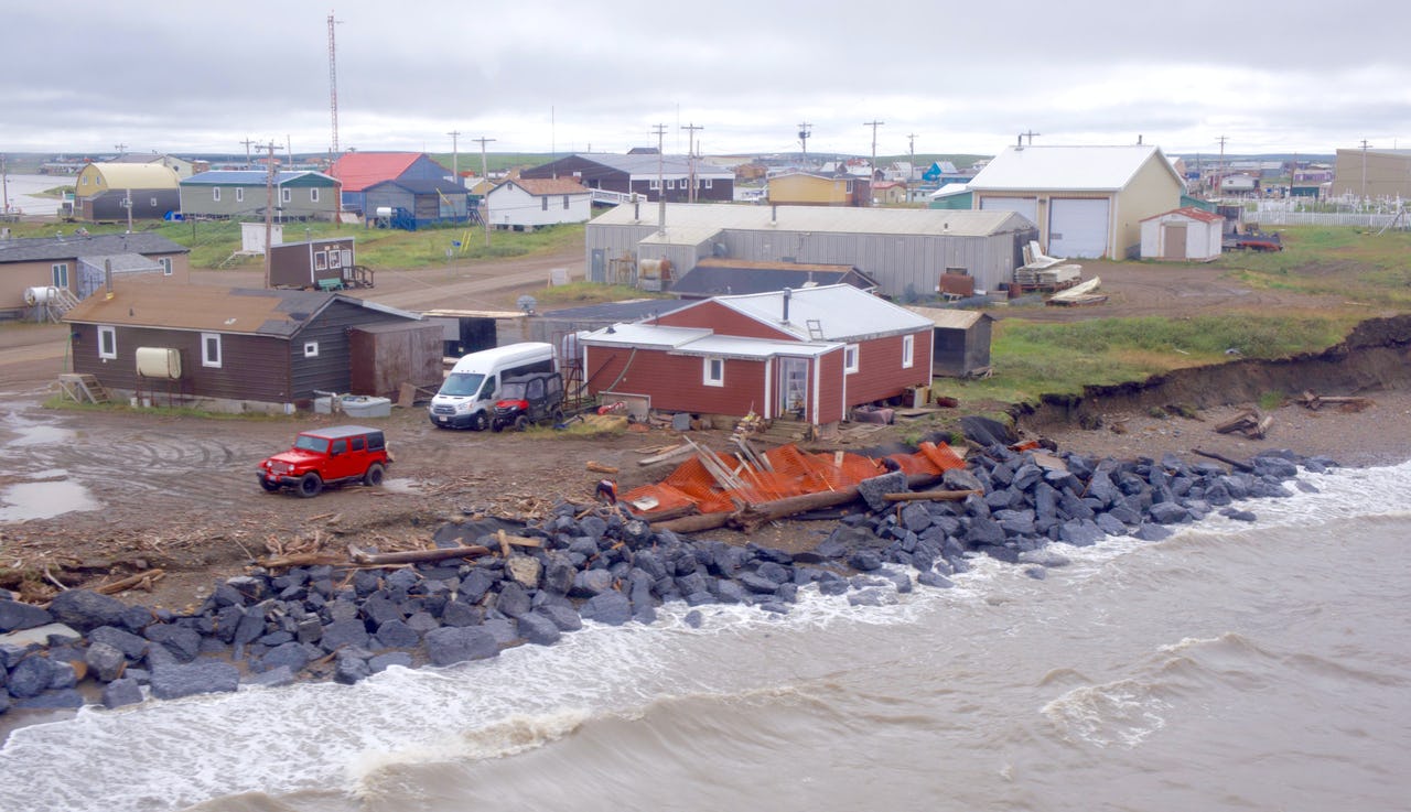
Noella Cockney’s house (center) in Tuktoyaktuk, the day after a storm in August 2019 that clawed away three feet of the eroding shoreline. Photo: Susan Nerberg
Permafrost thaw is one of the world’s most pressing climate problems, already disrupting lifestyles, livelihoods, economies, and ecosystems in the north, and threatening to spill beyond the boundaries of the Arctic as our planet continues to warm. To examine the effects of permafrost degradation, and increase our understanding of what this phenomenon means for the future of the region (and the world), The Arctic Institute’s new two-part permafrost series aims to analyze the topic from scientific, security, legal, and personal perspectives. The second installment of our series features eight new articles on permafrost degradation and its effects on Arctic life, research, and the world at large. But before, check out the seven articles from our first installment, starting with the Intro.
The Arctic Institute Permafrost Series 2021
- Agents and the Arctic: The Case for Increased Use of Agent-Based Modeling to Study Permafrost
- Drunken Forests: Teaching About Permafrost Thaw Through Personal Experience
- The Global Carbon Budget and Permafrost Feedback Loops in the Arctic
- Meltdown – The Permafrost that Holds the Arctic Together is Falling Apart
- Reducing Individual Costs of Permafrost Thaw Damage in Canada’s Arctic
- North but Maybe Not North Enough: Adapting Sub-Arctic Communities and Infrastructure to a Changing Climate
- Climate Change and Geopolitics: Monitoring of a Thawing Permafrost
- Infrastructure and Community Resilience in the Changing Arctic: Status, Challenges, and Research Needs
- Permafrost Thaw in the Warming Arctic: Final Remarks
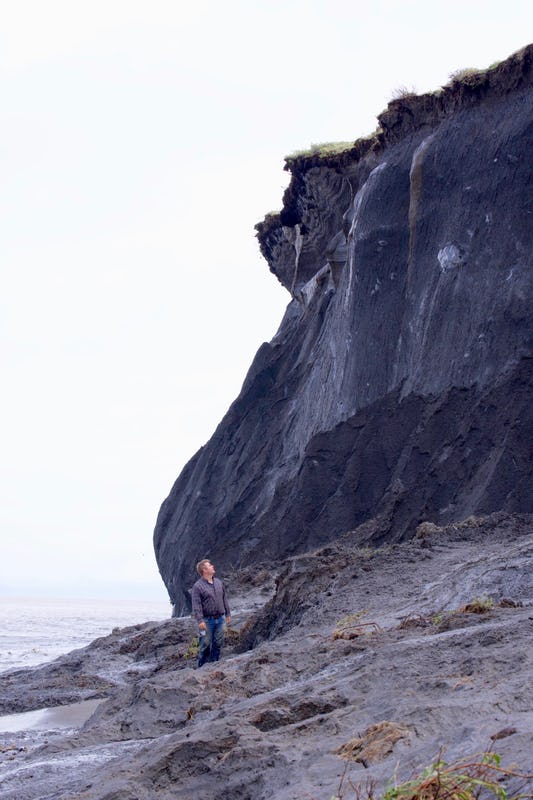
The sandhill cranes were obliviousto the destruction. About 500 metres from their tundra nest on Pelly Island in the Northwest Territories, a chunk of cliff four storeys high crashed into the ocean, sending the odour of broken earth and sulphur into the spray. The massive block of frozen mud and ice toppled so fast a group of scientists working nearby on the island’s shore didn’t have a chance to yell “Holy crap!” before it bombed the Beaufort Sea. But the sandhill cranes didn’t seem to notice, continuing their calls amid the rumble from the falling cliff.
If the catastrophic erosion of Pelly Island is an indication, climate change smells like brimstone and sounds like fury. Many of us living far from the lacy coastline of the Beaufort Sea are a bit like the sandhill cranes, however: too distant to hear the roar of fragmenting land masses, too distracted to grasp the unravelling of the western Arctic. But the frozen ground that since the last ice age has propped up the land of the Inuvialuit and the Gwich’in peoples in this vast region is thawing, leaving open wounds on the tundra and crumbling cliffs on the coast. As permafrost scientist Steve Kokelj of the Northwest Territories Geological Survey put it to me over the phone before I headed north in August 2019 to witness these dramatic changes, “When permafrost thaws, we’re losing the glue that holds the landscape together.”
For people living in the Arctic, climate change is hacking away at their foundation. It drives storm surges, washes out roads and clogs rivers with sediments. It produces sinkholes and triggers landslides capable of altering the topography and tilting houses. The climate crisis is even seen by some as a form of environmental racism — a problem created down south and suffered up north. Heavy fossil-fuel use at more southerly latitudes, mainly in North America, China and Europe, is driving the generation of human-made greenhouse gases, and the western Arctic and sub-Arctic are heating up twice as fast as the global average. In the past decade alone, the Arctic has warmed by 0.75 degrees Celsius; the Earth as a whole has warmed by at least 0.8 degrees — over the past 140 years. And while these local cataclysms may feel distant to southerners, their impact has worldwide repercussions. The bigger, global threat of permafrost thaw is the potential transformation of previously frozen organic matter into greenhouse gases that could further heat the planet. One of the questions scientists are trying to answer is whether the Arctic might be turning from a carbon sink into a carbon emitter — essentially, whether what happens in the Arctic stays in the Arctic.
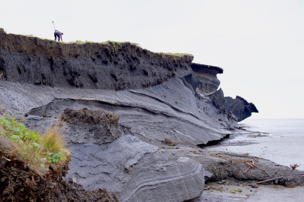
One in a string of outer islands in the Mackenzie River Delta, Pelly is perhaps the fastest disappearing island on the planet. Dustin Whalen, a physical scientist who has been tracking the region’s coastal erosion with Natural Resources Canada (NRCan) for 15 years, was one of the four researchers on the shore who blinked and missed the cliff collapse last August. He was still waving his phone — he had to get the after shot — when he called me over to the beach where he was standing. “Look north from here,” he said, pointing. “The land went way out, about a kilometre, 60 years ago.” If erosion continues at the same swift pace, the island will be swallowed by the ocean in another 50.
Whalen wanted to show me something else. He’d seen it many times before, but it was still as if he couldn’t quite believe it. Below Pelly’s cliffs, the island didn’t just ooze mud. It disgorged it, smothering the solid remnants of permafrost with a sucking noise. Rubbing the cold muck between my palms, I shuddered, as much with delight at playing with something from the last ice age as with horror at goofing around with something that should be frozen solid. In contrast to the tower that had come crashing down, the destruction in this spot sounded more like a sigh, as if the ground had given up.
Luckily, Pelly Island is uninhabited. The only living things I saw were the sandhill cranes and a lone grizzly bear stirred from its midday snooze by the whip of helicopter rotor blades. Unlike the bear, the cranes don’t remain north of the 66th parallel; in the late summer or fall, they leave for their wintering grounds in the southern United States and Mexico. But people north of the Arctic Circle, those most directly affected by the climate crisis, can’t easily up and go like migratory birds. An hour’s helicopter flight away from Pelly Island is Tuktoyaktuk, an Inuvialuit hamlet built at the end of a small peninsula that juts into the Beaufort Sea. On an evening stroll when the sun splattered gold on the hamlet’s colourful facades, Whalen told me a handful of people in the community have already had to move because their homes were in danger of slipping into the swell. They may be Canada’s first climate refugees.
Whalen was taking me to the Point. The spit of land, at the end of Canada’s first all-season road to the Arctic Ocean, is part of the most compromised area of the hamlet, battered by increasingly relentless waves. A couple of decades ago, a curling rink was destroyed near here because of advancing coastal erosion, and the RCMP detachment was forced to relocate. Today, the cemetery is at risk, and the nursing station is getting closer to the edge. Because of climate warming, sea ice forms later in the fall and melts earlier in the spring. With less ice to reflect the sun’s rays back to space, the thermal energy is absorbed by the water, and the longer season of open water gives the wind more time to whip up intense waves and storms. The waves claw away at the cliffs and expose the permafrost, speeding up its thaw and, in turn, causing the cliffs and shore to crumble even faster. At the current rate of erosion, the whole community of 950 people might need to relocate by 2050.
But Tuk is where the heart is. Sophie Stefure, a local resident who in the summer of 2019 was working as the production manager with the film-production startup Tuk TV, said during a coffee break that people don’t want to leave. “It’s our home. For people down south, it would be like losing your home without being able to do anything about it.” She joked the solution would be to get a houseboat, like Noah, and call it Sophie’s Ark. The reality is no joke, though. “It’s inevitable. Whether we like it or not, we’re going to have to move.”
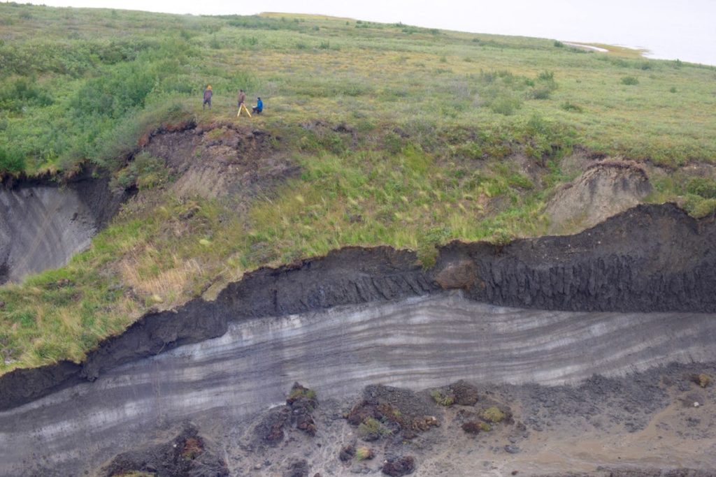
Permafrost belongs out of sight, under a layer of dirt. So when you come across it exposed, it’s a bit like driving by the scene of an accident: you want to look, but you don’t want to see. When curiosity takes over, you zoom in and realize that permafrost is a glimpse of the past: plants and animals that died long ago, compressed by the clamp of time but not necessarily decomposed because of the freezer-like conditions that have remained in high-latitude ground since the last ice age. This carbon-rich organic matter is streaked with clay, pierced by rocks, layered with silt and ice.
“The simple definition of permafrost,” said Chris Burn as we set out on the Dempster Highway last August, “is ground whose temperature remains at or below zero degrees year-round for at least two consecutive years.” A permafrost scientist and physical geographer at Carleton University in Ottawa, Burn has been doing fieldwork in the western Arctic and Yukon every year since 1983. For him, the 740-kilometre Dempster, which links Inuvik in the Northwest Territories with Dawson City in Yukon, is part of an annual migration route that takes him to permafrost and ground-temperature monitoring sites throughout the region. When he decided some 40 years ago to make permafrost the focus of his research, the concept of a greenhouse effect was new to him. “I had just started hearing about climate change and realized permafrost would be a realm in which one would be able to observe changes over the span of a human life,” Burn said. While some permafrost thaw can be a normal component of the northern landscape, back then he never could have predicted it would change so fast.
Half an hour after leaving Inuvik — the de facto capital of the Inuvialuit Settlement Region — Burn pulled over and stepped out onto the highway’s gravel embankment. Beside the road, there was a hint of a path cushioned by peat. Swapping his Blundstones for rubber boots, Burn explained that nearly half of Canada and almost a quarter of the northern hemisphere rests on permafrost. On the short hike to some thermistors (devices that record ground temperatures; on Burn’s route, the deepest is 50 metres underground), he said permafrost is unevenly distributed. These thermistors were drilled into the continuous permafrost zone, where pretty much all of the landscape is propped up by frozen ground. Dawson City, farther south, sits on discontinuous permafrost, where 50 to 90 percent of the ground is permanently frozen (the rest freezes only in winter).
Regardless of type and geographic area — the western Arctic, Siberia, Alaska — the foundation of the northern landscape is under threat. “Back in the ’60s and ’70s, we thought permafrost would be the same forever,” said Burn. “We thought of permafrost as being in equilibrium.” But already, there is 10 percent less frozen ground in the northern hemisphere than there was in the early 20th century; by 2100, 40 percent of all permafrost might be gone. On Garry Island, a little west of Pelly, where Burn continues the work of the late Ross Mackay, Canada’s originator of permafrost science, ground temperatures have increased by three degrees since Mackay’s measurements from 1969 to ’71. “There is much, much, much more activity now within the past 15 years than we can find in the record of the previous 10,000,” Burn said.
To what extent the land subsides and human structures — buildings, roads, pipelines, airstrips — tilt or buckle depends on how much ice is held in the frozen ground. As permafrost thaws, the ice in it melts. The more ice, the greater the impact on the landscape because more volume is lost as water; the soil gives way. Approaching the Northwest Territories-Yukon border, Burn pointed out the Million-Dollar Hole, a sinkhole on the side of the road that constantly has to be refilled with gravel to keep the highway stable. Soon after, we passed eight nearby landslides, likely set off by increasing summer rainstorms. On the opposite side of the road, he surveyed what scientists refer to as a retrogressive thaw slump, a type of landslide created when rain or a creek exposes ice-rich permafrost on a slope, causing a swath of ground to collapse when it thaws. Here, you could see the permafrost, its melting ice sending a stream of mud downhill. “It’s only a matter of time before it reaches the road,” noted Burn.
That’s the problem. Mudflows, sinkholes and washouts — and, in winter, ice plugs in culverts leading to flooding and freezing — cause maintenance-related highway closures. In 2016, for instance, a heavy rain washed out 14 spots and restricted traffic for a week. The Dempster, opened in 1979, connects communities that used to be fly-in or barge-in year-round; cutting this ribbon could threaten their food supply. What’s more, highway maintenance costs due to climate change alone hit an average of $5.3 million per year between 2013 and 2016, up from $1.7 million per year from 2005 to 2008.
The day before we set out from Inuvik, Burn told me there are three time scales to climate change. The slow curve is the long-term increase in ground temperatures since Mackay built his research cabin on Garry Island. The medium curve shows changes that have always happened but are now picking up speed and scale, such as the thaw slumps. This type of ground collapse is exploding in number across the Arctic, with the largest single slump, the Batagaika Crater, cutting a one-kilometre-long gash into the Siberian tundra. The third curve shouts out unprecedented large-scale events, like the catastrophic changes happening on the coast and in places like Pelly Island. We need to understand all three to make better predictions about the future and to manage change. Time is of the essence in the western Arctic — for the region’s residents; for the migrating caribou navigating troughs in ground that used to always be frozen; even for the highway maintenance crews heading out on the Dempster after heavy rain.
“We’ve always managed to engineer ourselves out of problems, but when it comes to climate change, it may be too late. Even if we stop all anthropogenic greenhouse gas emissions right now, the warming will continue for some time,” Burn told me. “I’m confident there will still be a world we recognize. But to paraphrase [British author] L.P. Hartley, we’re approaching an era when the past will be a foreign country.”
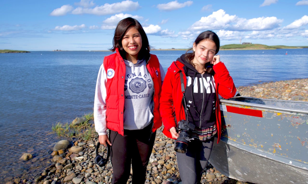
Regardless of where in Tuktoyaktuk people live, they’re all standing at a sort of precipice. That’s especially true for Eriel Lugt — the house she lives in is literally at risk of falling into the sea. One afternoon, after the high school student had finished her day shooting with the Tuk TV crew, she and her friend Carmen Kuptana walked me to the hamlet’s bayside, past driveways animated by playing kids. Lugt’s home, overlooking Tuktoyaktuk Island, seemed to teeter, one of its corner posts exposed. “My balcony, the railing is falling, getting pushed down,” Lugt said, looking up from the beach at the underbelly of the porch.
“On the map, Tuk is a little spit,” she said. “If people realized that that little spit has people like us [living on it], they’d think, ‘Is that actually a place? Can you go there?’ They need to understand that the ocean is coming in, and we’re worried about our land coming off the map.” For Kuptana, the climate emergency isn’t just changing the land; it’s changing Inuvialuit ways and culture. “There’s so much land that we use, but it’s being erased because of erosion and climate change,” Kuptana said. “Our weather and currents didn’t use to be like this 50 years ago.”
The risks facing the community prompted Obie David James Anikina to become a climate monitor with the Tuktoyaktuk Community Corporation’s climate-resilience project. Launched in 2018 to track climate-change indicators, including ice thickness, vegetation shifts and permafrost depth, the federally funded project brings together local knowledge and scientific methods of data collection. Whalen and some of his NRCan team members provide training support, and their research, in turn, is boosted by the climate monitors’ work overseeing a weather station year-round. Anikina started hunting game and foraging for berries as a young adult, enjoying the adventure of being out on the land. The 49-year-old has seen significant changes over the past two decades. “I wanted to know more about climate…why it’s changing and what the outcomes are,” he said after a shift counting berries to track the impact of warming on traditional foods. “And I want to be able to tell the younger generation.”
Youth, for their part, want to tell the world. For Lugt and Kuptana, climate change isn’t only a question of what’s happening at home. They want people in the south to see the consequences of overconsumption. As part of Tuk TV, which started as a storytelling project in school and has since become a social enterprise with paid commissions, they and five other teens made the documentary Happening to Us. The girls went to Madrid for the film’s international premiere at the United Nations’ COP25 climate change summit in December 2019. “I hope to change all the young people’s minds. I want everyone my age to be worried about what’s going to come in the future,” Lugt said, sitting on a boulder on the beach by her house. “Down south, people work, work, work and pay taxes, and what’s that all for?” she continued. “If they stopped to see the beauty of nature, they wouldn’t care about buying stuff that makes climate change happen.”
Anyone who’s been to the Arctic in summer can attest to the relentless swarms of mosquitoes. At times, they descend as clouds that momentarily make them the biggest menace on Earth. But as Paul Mann swatted the air, wishing he’d brought his beanie, the Beaufort breeze that blew in over Peninsula Point, southwest of Tuktoyaktuk, was enough to deter an onslaught. The more sinister threat to Mann, a polar scientist and associate professor of geography and environmental sciences at Northumbria University in England, was the one lurking underground.
When the United Nations’ Intergovernmental Panel on Climate Change (IPCC) wrote its major assessment reports, carbon stored in permafrost wasn’t factored in to the projections. But as permafrost thaws and breaks open, the carbon-rich organic material that has been locked away, for some 10,000 years in the western Arctic or even 100,000 in parts of Siberia, becomes fuel.
“Permafrost is like frozen pizza for bacteria,” said Mann. “Climate change is their microwave.” As the permafrost thaws, microbes that had been dormant spring to life, ravenous after their long fast. When the permafrost they are lodged in is exposed to air, they convert the carbon to carbon dioxide. Without oxygen, such as under lakes and ponds, they belch methane, which isn’t as long-lived in the atmosphere as carbon dioxide but is about 30 times more effective as a heat-trapper over 100 years. Carbon dioxide, on the other hand, can remain in the atmosphere for thousands of years. Increasingly, Mann and other researchers are detecting nitrous oxide from cracks in the ground created as permafrost thaws; as a greenhouse gas, it is nearly 300 times more potent than carbon dioxide over 100 years. When these gases enter the atmosphere, they’ll cause more warming, leading to faster thaw and even more exposed carbon converted to heat-trapping gases. “There’s nothing positive about this positive-feedback loop,” Mann told me. Scientists estimate that the carbon held in frozen ground amounts to some 1,600 gigatonnes — twice the amount that is currently in the atmosphere.
All of this means that permafrost thaw is a much more alarming global threat than previously anticipated. Not only is there abrupt permafrost thaw in summer; it’s also happening in winter, releasing carbon dioxide when there are no photosynthesizing plants to absorb it. Over time, the Arctic might start to vent more carbon dioxide than it stores. “I’ve already been going through the grief,” said Mann about the distress triggered by the climate emergency. “Now we need to document what’s happening in the Arctic as quickly as possible. Climate change is taking place faster than we can track it.”
Indeed, the urgency of the research is what brought Mann here, part of a 14-person international dream team of polar scientists collaborating across borders and disciplines to better understand an issue of planetary concern. While Mann was in this part of the Arctic for the first time, some of his colleagues had several seasons in the field. That day at Peninsula Point, Mann was drawing gas samples from the soil into glass vacuum tubes using a long syringe. Others whizzed drones back and forth to map the changing coast or sampled ice and melt-water for chemical testing. The data collected by the group will eventually create a multi-layered picture of the changes, what prompts them and their impacts. These details can be used to more accurately predict future changes and help communities, including Tuk, adapt and plan where and where not to build homes.
During a lunch break on the tundra, tiny willows as his cushion and the fluffy white blooms of Arctic cotton as the backdrop, Mann was thinking about the future. “Are we so foolish as a species that we saw what was happening, and even measured it, but did nothing?” he said with exasperation. “That’s really stupid, because it means we were more interested in chasing little green bits of paper.”
For a visitor, it was hard to imagine that a storm was approaching Tuktoyaktuk. The Beaufort Sea looked serene, heavy even, a thick layer of shimmery paint from an artist’s brush. For the locals, these golden hours last August were the calm before the arrival of near gale-force winds that would rip through their hamlet at 60 kilometres an hour. They used the time to haul boats up on land and pull skidoos away from the shore — to batten down anything that wasn’t secured.
The storm season used to begin in August, but now storms are happening more frequently and as early as July. For Whalen and his team, the weather event was an opportunity to study how climate-change-driven storms accelerate erosion. Waves have always nibbled away at the coast. Now, with shrinking sea ice and more frequent storms, the waves take chunks. That evening, Whalen and two colleagues set out from the hamlet in a Zodiac toward Peninsula Point. He picked a spot in the sea about 800 metres out from the thaw slumps that had been the focus of their attention for the past few days and lowered an oceanographic mooring into the blackness. Once the storm hit, this underwater set of devices, anchored to the sea floor, would record the speed of the current and the size and direction of the waves, as well as turbidity, looking at the flow of permafrost sediment from land.
As the winds bore down on Tuk, residents like Sarah and Sandy Adam and their neighbour Noella Cockney huddled in their homes on the ocean side of the spit, hoping driftwood would not come crashing through their living-room windows and that the concrete reinforcements on the shore would keep their houses standing. That night, workers went to Cockney’s place, the most critically endangered of the houses. They dumped gravel by her front steps, trying to secure the entrance from slipping into a void.
The following day, all the houses were still standing. The Adams sat outside their vestibule, relieved they hadn’t lost anything. But one of the corner posts was getting dangerously close to the edge. Nodding toward it, Sandy said the storm had taken more than half a metre of the shore despite the reinforcements. He shook his head and ventured inside. While he was fussing over a caribou stew, Sarah told me they’d lived in the house since 1994 and were still paying taxes on land that had disappeared into the ocean. She looked out at the storm-churned murkiness of the water. When the couple were children, there was a 400-metre stretch of beach to play on.
That beach seemed like a distant memory to the Adams. But for Whalen and his team, tracking the cataclysmal transformations on the coast, and Chris Burn, measuring the incremental changes along the Dempster Highway, it was as if the ancient past suspended in the permafrost was catching up. Time was running out for them to understand the speed of the disruptions underway. For Carmen Kuptana, the explanation for what was happening in her part of the world was obvious. “It’s sad that people would want to ruin our land for oil, for money. How greedy can you be?” she told me two days before the storm. “People count on the land for food, they spend time there with their families, and you just want to [ruin it] for a worthless paper bill?”
The Arctic catastrophe is everyone’s emergency. In Tuk on the day after the storm, the scientists headed out to survey the alterations wreaked on the shoreline. On Tuk Island, waves had pounded undercuts into the cliffs, laying bare the permafrost and forming piles like stalagmites out of the disintegrating ground. Peeking into these cavities was at once fascinating and terrifying: you wanted to look, but you didn’t want to see the dripping mud tracing the shape of things to come. Because you knew the future was a foreign country.
Epilogue
In the spring of 2020, four of the houses on the Point in Tuktoyaktuk, including those of Sarah and Sandy Adam and Noella Cockney, were moved to gravel plots at Reindeer Point, a subdivision about eight kilometres from their former address. (The gravel insulates and protects the permafrost underground.) Changes were also a reality for the scientists in our story, but for a very different reason. In response to the COVID-19 pandemic, the Northwest Territories and Yukon introduced border restrictions for non-residents and non-essential workers, threatening field research. So in the summer of 2020, Chris Burn and Dustin Whalen found ways for local residents to check up on experiments, boosting their role as monitors.
This story first appeared in the September 2020 issue of Broadview magazine. Susan Nerberg is a science and environmental journalist in Montreal.