Search For Sovereignty: Historic Shipwrecks in the Canadian Arctic
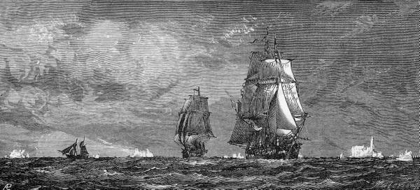
Ill. of the ships “Erebus” and “Terror”, belonging to the arctic exploration team led by Englishman John Franklin, head into the ice floes of Baffin Bay towards the North Pole, from which they never returned. Photo: LIFE
Parks Canada, the country’s national park agency, recently concluded its latest search for the shipwrecks of the HMS Erebus and HMS Terror, which were lost in what has been called the “worst tragedy in the history of Arctic exploration.”
Arctic explorer Sir John Franklin set off on May 19th, 1845, intending to map the middle section of the Northwest Passage. Now Canadian officials are using this historic expedition to boost Canada’s claims to Arctic sovereignty, hoping that discovering the wrecks will bring international attention to Canada’s Arctic history. Additionally, both historical and contemporary searches for these famous ships have led to increased charting of the Canadian Arctic territory.
Although interest in recovering the Erebus and the Terror has existed since the ships went missing, the Canadian government has renewed its efforts since 2008, when the recent series of explorations was launched as a collaborative effort between Parks Canada, the Canadian Hydrographic Service, the Canadian Coast Guard, and the Government of Nunavut.1)
At the launch of the expedition, the Minister of the Environment (in 2008—now serving as Canadian Minister of Foreign Affairs) John Baird stated: “We certainly think by establishing a long-standing presence in the Arctic that can enhance issues of sovereignty … Look at the strait (the Northwest Passage) not far from where this ship is….We think every bit of weight we can put behind our case for sovereignty is important. Adding history to that equation can only enhance that case.”2)
The 2008, 2010, and 2011 missions have all failed to locate the Erebus and the Terror.3) Although the discovery of the ships has been the most pronounced goal, Parks Canada has announced that the expeditions continue to map uncharted waters and “contribute to improving charts of the Canadian Arctic.” In addition, the 2010 search yielded the discovery of the HMS Investigator, a British expedition ship abandoned in the Canadian Arctic in 1853.
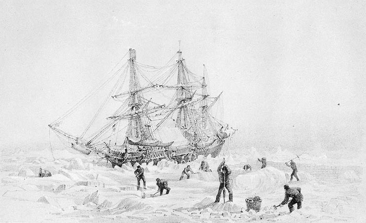
#/media/File:HMSTerrorThrownUpByIce.jpg)
Coincidentally, mapping uncharted Arctic territory was also a goal of the Franklin Expedition. Franklin, a veteran of Arctic mapping expeditions, set sail on May 19th,1845 with 129 crew members.4) The two ships became immobilized in ice floes in 1846 in the Victoria Strait near King William Island. About a year after Franklin’s death in 1847, the crew members, suffering from health problems like tuberculosis, scurvy, and lead poisoning, decided to abandon the ships and seek help on foot.
Between 1847-1887 more than 26 searches for the ships were conducted, but none of the crew members was found alive. Although unsuccessful in finding survivors and shipwrecks, these expeditions produced more detailed maps of the Canadian Arctic.5) Search missions continued through the twentieth century, leading to the remarkable discoveries of three frozen, mummified bodies, an expedition note, and bone fragments.
In 1992, the yet-undiscovered wreck sites were declared National Historic Sites of Canada, and in 1997 the UK and Canada signed a Memorandum of Understanding that the ships belong to Canada.
According to Baird, the Canadian Arctic lacks some international legitimacy: “it’s certainly part of what we call Canada; others don’t necessarily recognize that claim. So we’re committed to doing everything we can to have a presence in the north – environmentally, whether it’s establishing a long-standing presence and history, whether it’s resource-based, whether it’s militarily…”.6)
By continuing to research and explore the Arctic, the Canadian government is continuing Franklin’s mission of mapping remote territory. While Franklin “had put a roof on the map of Canada, and given a definite shape to the North American Continent”,7) the Canadian government is ensuring that the “roof” of the country continues to be a recognized part of Canada.
References