Establishing Maritime Boundaries in Arctic Waters
Where’s the boundary? Photo: Tiago Fioreze
Arctic states are increasingly engaging in boundary-making at sea: the process of delineating areas of rights and responsibilities in the north. This entails drawing lines on a map to decide “who is allowed to do what in which area”, but also establishing rules and regulations to prevent harmful effects on the environment and people as human activity grows. These efforts are in turn crucial for the trajectory of economic development in the north.
Linking boundaries and economics
As in many parts of the world, boundary disputes also exist in the Arctic. Their significance, however, is not their potential for confrontation but the hampering of cooperation and in turn the economic development that Arctic states seek. Oil and gas projects need clear boundaries to proceed. Fisheries quotas are determined partially with reference to maritime zones. Shipping needs clear divisions of responsibilities in case of an emergency. Within the maritime domain, establishing clear boundaries can be a positive-sum game, where all parties benefit from progress.
Settling disputes
In 2010, Russia and Norway settled their maritime boundary dispute in the Barents Sea after almost four decades of negotiations. A thorn in their relationship, removing this dispute was crucial for the larger security relationship between the two states. The settlement also had additional ramifications. Albeit well managed already before 2010, establishing clear boundaries simplified the management of the highly lucrative fisheries that cross between Russian and Norwegian waters in the area. Similarly, emergency response cooperation – i.e. search and rescue and environmental crisis management – has expanded since the agreement.
In the final agreement, the two countries also agreed on provisions for cooperation in the management of any hydrocarbons that straddle the boundary through a unified development of such resources (so-called unitisation).1) A somewhat similar agreement giving each state a 25% share in potential resource development was put in place between Iceland and Norway when settling a dispute over the economic zones around Jan Mayen.2) Such inventions enable states to overcome their fear of hindering economic development.3)
In other parts of the Arctic, however, disputes remain. Most noticeable due to its size is a maritime boundary dispute between Canada and the United States in the Beaufort Sea.4) Looking beyond the Arctic, more than 200 hundred maritime boundaries are still disputed all across the world’s oceans.5)
What are maritime boundaries?
In contrast to territory on land, states do not permanently occupy maritime areas. Maritime zones and boundaries are the invention of a legal regime that has developed over the last century.6) This legal regime entitles each coastal state to rights in the adjacent maritime space: a maximum 200-nautical mile exclusive economic zone (EEZ) and continental shelf, which can be extended further given adequate proof of its geological contiguity. Entitlements to rights at sea and the continental shelf (like the exploitation of marine resources) are the expression of a state’s territory on land. It is the shape and size of this that determine what can be claimed at sea. Thereafter, maritime boundaries between states are used to delineate both these zones of rights.
Entitlement to maritime space does not, however, give states the right to exclude foreign actors from this domain (as a border on land entails). This is crucial as we cannot equate borders on land to boundaries in the maritime space, a popular fallacy prevalent in descriptions concerning maritime disputes in the Arctic and elsewhere.7) Instead, a maritime boundary only delineates sovereign rights of a given state within the maritime domain. In turn, this enables the state to exploit resources in the water column and on the seabed, and regulate related environmental issues.
Establishing clear maritime boundaries between states – based on the Law of the Sea Convention – also requires cooperation. Cooperation takes the form of dialogue, negotiations, and agreeing on compromise in favor of the larger goal: undisputed zones of rights and responsibilities. At the same time, boundaries are crucial for fostering cooperation. Having defined maritime domains enables states to cooperate more easily on issues such as transboundary resources and environmental protection. This relationship is thus circular and interconnected, as we cannot separate one aspect from the other.
Everyone wins?
By settling maritime boundaries, states are able to engage in previously impossible resource development and joint extraction activities. Fishing rights and quota management similarly become easier to facilitate. Clear jurisdictions about ‘who has what rights in which area’ enable states to cooperate, for example on resource development projects. Although the loss of rights is in itself a zero-sum game due to the nature of delineation, joint management of transboundary resources constitutes positive-sum situations with mutual gains.
This leads to the question: If boundary dispute settlement is a positive-sum situation, why are disputes still outstanding? In the Arctic, the Beaufort Sea dispute between Canada and the United States seems ripe for settlement. Yet, as recently examined in an article that compares Canada’s and Norway’s maritime boundary disputes, the process of resolving such disputes is not as straightforward as it might seem.8)
The fear of being seen as ‘giving away’ rights to maritime resources in tandem with difficulties of convincing domestic interest groups of the positive-sum outcomes seem to be the main barriers in the specific case of the Beaufort Sea. It can be easier to ‘manage’ the dispute instead of settling it.9) This might not be the ideal scenario but it can be the consequence of limited attention paid to the dispute, or not being able to attain a mutually agreeable outcome. One way of overcoming fears of loss would be instilling cooperation on resource management in boundary negotiations. Another is increased publicity around the positive effects of settlements – such as the removal of barriers to economic projects – aimed at a domestic audience.
Areas of responsibility
Another dimension of boundary delimitation in the Arctic is the growing pressure to delineate areas of responsibility and competence within the maritime domain. This concerns drawing boundaries of ‘who does what’ and ‘who is allowed to do what’ as certain types of activity increase in northern waters. A clear example of this is the recent agreement to not allow commercial fisheries in the international waters of the Arctic Ocean for the next 16 years, signed by 10 countries on November 30, 2017.10)
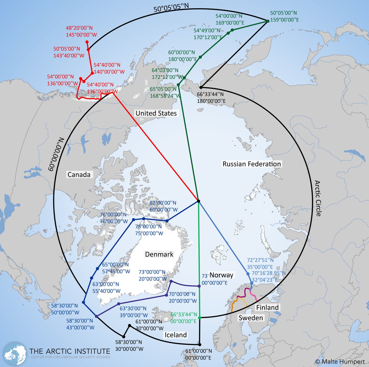
The agreement on Search and Rescue in the Arctic negotiated under the auspices of the Arctic Council from 2011 is another example (see map below).11) By clarifying not only zones of responsibility but also procedures for joint efforts in the case of an emergency, boundaries enable states to better respond to demands of improved crisis response in the Arctic. Similarly, by creating regulations for Arctic shipping through the International Maritime Organization’s Polar Code, states are trying to ensure higher safety standards in Arctic waters.12) Moreover, there has been continuous work over the last decade on harmonizing operating conditions concerning oil and gas activity across the region, although these still remain voluntary (like the Arctic Council working group PAME’s guidelines for petroleum activity).13)
These examples highlight how boundaries do not only concern the delineation of rights within a maritime space but also the delimitation of responsibility and competence. Yet, the latter is dependent on the former. States need clear maritime boundaries to better put in place zones of responsibilities.
Maritime boundaries and Arctic development
There are some commonalities between the various forms of boundary-making described above. First, the process of establishing boundaries in the Arctic has been driven by the increased attention the region has received over the last decade. Commercial actors interested in marine resources located in disputed areas spark interest among state actors in resolving these disputes. The same activity also requires Arctic states to coordinate their regulatory regimes and emergency response mechanisms, given challenges concerning vast distances in the region and limited available infrastructure for search and rescue and environmental protection.
Second, establishing or settling these boundaries are not end goals in themselves. These are only small building blocks in the development of a more comprehensive governance system in the Arctic. This governance system – and the clarification of roles, rights, and responsibilities that follows – sets the parameters for Arctic economic development. Despite fluctuating commodity prices and geopolitical tensions, the Arctic regions and their inhabitants are still working hard to realize the economic development envisioned when an ‘Arctic boom’ was forecasted over the last years. The key is therefore to comprehend the interplay between these development aspirations, cross-border cooperation, and boundaries.
References