Media Coverage of Climate Change Relocation in Alaska
This aerial shot of Kivalina, a Alaska Native Village facing shoreline erosion, was taken during the Kotzebue ShoreZone Survey in July 2012. Photo: ShoreZone
The following is an excerpt from the article “America’s First Climate Change Refugees: Victimization, Distancing, and Disempowerment in Journalistic Storytelling,” first published in the journal Energy Research & Social Science. The full journal article can be accessed at ScienceDirect here.
Media coverage of Alaska’s first climate refugees has extended across national and international geographies of publishing over the past five years. And yet, while accounts of climate relocation in the American Arctic and sub-Arctic are written and printed re-currently, most readers will never physically visit Alaska’s eroding edges. Rather, they come to know the story of relocation through visual media narratives. Photographs, maps, and newspaper illustrations serve as referents for readers to make meaningful judgments and legitimate knowledge claims about coastal communities in need of retreat. Images of eroding shorelines and sea level rise found in news articles like those mentioned above enable both the general public and policymakers to examine, order, and evaluate the plight of relocation. But visual storytelling isn’t an objective reflection of reality or truthfulness. Like art itself, journalistic images are engendered by their creators’ biases and patrons’ desire.1) They present a subjective, curated narrative produced to buttress broader strategic political initiatives and themes. Each selective compositional or contextual element evokes a specific perspective about sea level rise and relocation in Alaska dependent on particular visibilities and invisibilities. In consequence, by choosing what to represent, how, and who, journalists allow a limited and specific kind of understanding of climate relocation in the Arctic, with very real political and ethical consequences.2)
This piece for The Arctic Institute is taken from a previously published article in Energy Research & Social Science titled “America’s First Climate Change Refugees: Victimization, Distancing, and Disempowerment in Journalistic Storytelling.” The original analysis aimed to delve deeper into the underexplored but critical role visual representations play in constructing a public narrative of climate change relocation in Alaska. Through a visual discourse analysis of American news sources that portray ‘America’s first climate change refugees,’ the article explores how media outlets are using images to construct perceptions of meaning, purpose, and power in stories of climate relocation. It will argue that journalistic storytelling of sea level rise and relocation has employed a formula of crisis, ‘othering,’ and victimization in representing the nexus of environmental change and culture in Alaska Native communities. Through this, the article will show that images have helped to construct and condition perceptions of agency in Alaska’s climate discourse that distance and disempower at-risk coastal communities from the reader.
“This is climate change:” President Obama and Arctic climate refugees
In August 2015, President Barack Obama became the first sitting president of the United States to visit the American Arctic. With much anticipation, Air Force One made the long sojourn North to visit first Anchorage, then Kotzebue a few days later on the cusp of the Arctic Circle. The White House made clear in no uncertain terms the reason for the historic trip: “President Obama traveled to Alaska to shine a spotlight on what Alaskans in particular have come to know: Climate change is one of the biggest threats we face, it is being driven by human activity, and it is disrupting Americans’ lives right now”.3) The impetus for the trip was the US Department of State’s Global Leadership in the Arctic: Cooperation, Innovation, Engagement, & Resilience Conference, held on August 30–31, 2015 with audiences from all eight of the Arctic nations and many observer states to the Arctic Council. The Conference was meant to generate momentum and expedite progress in addressing some of the most pressing issues facing the region, chief among them climate change adaptation and mitigation ahead of COP21 (the 21st session of the Conference of the Parties to the United Nations Framework Convention on Climate Change held in Paris in December 2015).
But the real spotlight only came to fruition during his three-day journey after the conference’s conclusion. In Instagram posts and handheld video footage from a GoPro, President Obama hiked a receding Exit Glacier to show America “as good of a signpost of what we’re dealing with when it comes to climate change as just about anything”.4) With photographs and blog entries, he boasted of a successful fishing trip at Dillingham in the heart of Bristol Bay’s salmon fishing district and warned of once frozen tundra transforming into scrub forest in just a few decades. And in a final thrust to use all available visual fanfare, President Obama shared his first and only visit as President 26 miles above the Arctic Circle to a global audience. Kotzebue, a village of 3000, is located on the shores of the Kotzebue Sound and has seen significant coastal erosion from sea level rise, disappearing shore ice, and more intense Arctic storms. President Obama’s visit to Kotzebue was perhaps the most pertinent iteration of the trip’s theme – traveling to “the frontlines of our fight against climate change” to see first-hand what future awaits the rest of the world. And although Kotzebue itself is not in imminent threat of being inundated within the next several decades, it served as an entry point to discussing those neighboring villages in the region that will be underwater within our lifetime. During his speech at Kotzebue High School on September 3rd, President Obama alluded to this reality.
I met Alaska Natives whose way of life that they’ve practiced for centuries is in danger of slipping away. On Monday, one Alaska Native woman told me she doesn’t want her way of life to go on the Endangered Species List. And I’ve talked with folks whose villages are literally in danger of slipping away. So on my way here, I flew over the island of Kivalina, which is already receding into the ocean. That’s what Millie was talking about. Waves sweep across the entire island at times, from one side clear across the other. And for many of those Alaskans, it’s no longer a question of if they’re going to relocate, but when.5)
While President Obama only flew over the village of Kivalina en route to Kotzebue, dozens of print media journalists made Kivalina’s plight of relocation the focus of their climate change storytelling around his visit. With headlines like, “Will these Alaska villagers be America’s first climate change refugees?”, these news stories do Law’s work of framing reality in a particular way – as one of crisis and victimization – to produce a persuasive account about the structure and organization of the natural and social worlds.6)
“Stay or Go?” The vote to relocate Shishmaref
Much like Kivalina, the Native village of Shishmaref is located on a barrier island in the Chukchi Sea, Sarichef Island, north of the Bering Strait and five miles from mainland Alaska. Its population of around 600 people, mainly Inupiat Native Alaskan, have lived a subsistence-based lifestyle of hunting marine and land mammals and berry picking at the current site as a summer camp for 400 years.7) The residents of Shishmaref have seen erosion on the island since it became a permanent settlement in the 1950s. However, with warmer air and sea temperatures from global climate change the sea ice pack that usually develops in the fall months, which is the island’s only buffer against severe storm surges, has begun to melt at an unprecedented pace. This lack of natural defense, combined with the effects of thawing permafrost on the island, have resulted in a loss of three to five feet of shoreline per year, with a single severe storm causing up to 50 feet of erosion.8)
The total island is ¼ mile-wide and three miles long. Although the village has constructed a number of manmade defenses, like the current sea wall, over the past several decades, the intensity of the erosion has resulted in damage to their streets, water and sanitation lagoons, and a number of homes being lost to the ocean. In 2002 Shishmaref voted to relocate their community to a new site on the mainland, Tin Creek. However, with a lack of funding and melting permafrost at the proposed site, the plan to relocate never came to fruition.9) After over a decade of inaction, on August 16, 2016 the City Council of Shishmaref again held a vote to either relocate the village to one of two nearby sites or to protect it in place. In a narrow margin, the vote to relocate passed 94–78 votes.10)
While the move to a new site still has several more steps, including a second vote to decide which site to move to and finding financial assistance for the relocation, the story-telling of their decision took news headlines by storm as the vote unfolded.
Different stories, shared visuals: towards a national narrative of climate-induced relocation
In each of these iconic news moments, both reader and subject are seemingly connected through a shared American citizenship and wider membership to a global human civilization at existential risk to a changing climate. After all, as President Obama notes in a video leading up to his 2015 Alaska trip, “What’s happening in Alaska isn’t just a preview of what will happen to the rest of us if we don’t take action. It’s our wakeup call”.11) Still, in spite of this collective threat to residents across the country and world, there is a distancing through the visual storytelling of Kivalina and Shishmaref as places on the edge of the nation’s physical borders, on the periphery of its national identity, and on the margins of the American experience. Three visual tropes seen in articles of each event form the contours of this distancing.
They accentuate particular visual elements of relocation, while omitting others, that have been seized upon as representative of the whole climate migration story, a story that transcends the localized details of geographies and temporalities. They are (1) the aerial photograph of the eroding landscape; (2) the image of dilapidated, damaged infrastructure; and (3) snapshots of children playing in physically disappearing hometowns. This expert will focus on the first of these elements.
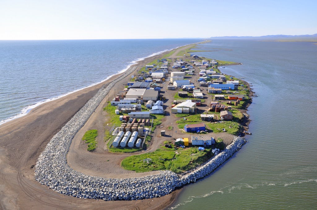
Victimization: the flyover, a birdseye view, and the power of the aerial
The image of Kivalina from the air is stark. Minute square homes cluster together at the tip of a long thin barrier island. The spit’s tail rises just above the waves. It slinks into the distance to connect to the mainland off camera, leaving just the crowded houses, a robust wall of rocks, and a paved airstrip visible. The photograph takes many accreditation iterations across articles, shot by both newspaper photographs of outlets like the Associated Press and by on-the-ground activist groups like Re-locate Kivalina. And while the angle and shutter speed are distinct in each photo, parallel visual notes echo across them all. There are no humans in Kivalina at this height. Although the island is clearly inhabited, the focus of the aerial shot is not one of its at-risk residents. It is of the environmental crisis at hand. In much the same way that Romantic painters captured the immense, uneven relationship between man and sublime nature in the 19th Century, so too does the aerial photo of Kivalina tells a story of mankind’s struggle with an unforgiving planet earth. Here nature is omnipotent and omnipresent. The blue of the surrounding Chukchi Sea and Kivalina Lagoon swallow the island in the visual frame, making the manmade structures seem insignificant and fragile. The sea seems inches away from the outer homes at this angle (the actual distance being three feet), and the seawall, though mighty, appears too small to make a difference if a wave were to sweep over the island.
The aerial shot of Kivalina framed by the wing of Air Force One may be unique, but the visual of a disappearing island on the edge of the American landscape is not. The same iconic image of an island being washed away is also reproduced in stories of Shishmaref the following summer as they voted to relocate. The particular photograph used and reused by outlets like United Press International and Popular Science is an aerial shot from Wikimedia Commons by the Bering Land Bridge National Preserve.12)
There again is photographed a thin barrier island from above, with rows of homes and a dangerously rough sea and flooding lagoon encroaching from both sides. As with the others, there is no visual high ground and it is easy to imagine the entire village becoming inundated in a single storm surge. The aerial image helps to construct two facets of the narrative of American climate-induced relocation. First, it promotes the theme of a shared, singular experience across geological, cultural, and climatic diversity of villages at risk to sea level rise. And second, the image of an overwhelming landscape and hostile textual support graphs a Western romanticized relationship between community and nature that masks the intimate and mutually empowering relationship coastal villages have with their ecosystem. The aerial view of the disappearing American island is what Rob Shields defines as a “place-image,” a set of core characteristics that form a widely disseminated and commonly held image or set of images of a place. In pace-images, those essential characteristics of a place or space hold strongly in society despite the specifications of and changes in local geopolitical environments.
In this way, the experience of each of these communities is flattened into a very particular concept of what climate-induced relocation should look like. It disenfranchises communities from their distinct local histories that have come to uniquely define each village. So while Kivalina and Shishmaref are all culturally distinct, in lieu of the visual multiplicity of each tribe’s heritage, the most popular image to emerge in each moment is the flat, universal image of a disappearing island. It is an image above the rich diversity of cultures, one that is easily recognizable as an image of climate change in America today without having the particulars to identify it as a unique community.
One of those immediately recognizable characteristics that make these photographs place-images is the overwhelming seascape that surrounds the island. The silhouettes of 19th Century artistic preference for a sublime, dangerous natural landscape seen in photographs of villages are, much like the colonial policies that have ruled them for a century, of Western intervention. They invoke a Euro-centric view of the ecosystem, an antagonistic relationship of the natural elements waging war against human settlement through climate change impacts. There are shared sentiments between Western Romanticism and the Native way of life: nature as inspiration, an immense beauty, and a powerful force to be respected and revered. But these commonalities are not represented in the supporting text. Adversarial discourse and warlike terminology is used throughout articles, like Mashable’s 2016 feature on Shishmaref’s relocation vote – “Shishmaref, Newtok and Kivalina have long been viewed as communities that are on the front lines of climate change.”13)
While Native American and Alaska Natives hold a deep respect for the powerful, and at times fatal dangers of the waters that surround them, the combative language does not represent the whole of their relationship to nature. These villages have lived with the water and surrounding landscape for centuries. Subsistence food such as fish, walruses, seals, whales, moose, and caribou are an important cultural, nutritional, and economical part of coastal village resident’s diets in Alaska.
There is a deep heritage in their relationship with nature, forming much of the traditional knowledge that is not only an integral part to each community’s culture, but also makes communities resilient to a changing climate. Traditional knowledge is defined as a living body of information that has been developed, sustained, and passed on from generation to generation. It is a set of practices and beliefs about the relationship of living beings to one another, their environment, and their culture that has both everyday applications and multigenerational relevance. In climate change research, traditional and indigenous knowledge is increasingly recognized as an important component of understanding weather patterns, ocean phenomena, and other ecological changes through personal observation. It helps construct historical, earlier environmental baselines and provides observational evidence for modelling.
Importantly, it complements Western scientific data, filling in observation gaps and supplementing scientific findings on shifting atmospheric and oceanic systems. Traditional knowledge imbued in the relationship between village and nature also helps coastal residents adapt to climate change. It passes down important lessons on how to read a changing landscape for personal safety, how to watch a changing hunting season to limit food security issues, and how to build infrastructure that is mobile and flexible to move with, not against, nature. These traditional knowledges are also unique to each community, in no small manner due to the diversity of the ecosystems.
Beyond the general village-nature relationship, none of the rich, empowering aspects of these geographic-specific knowledges are seen in the visual of a desperate island being swallowed by the sea and corresponding militaristic textual discourse. By making these empowering relationships with nature invisible through the singular, aerial photograph of these connected yet distinct communities, the only available narrative for readers is one of victimization. The Native relationship with the landscape is not the only relationship obscured by the bellicose language used in climate change relocation journalistic storytelling. The described conflict between nature and human omits the cause of more intense storms and rising sea levels: the emission of greenhouse gases. This invisibility of the relationship between Native coastal villages that produce little emissions with those more closely related to large-scale emissions, such as fossil fuel extraction and carbon-intensive, auto-focused lifestyles visually moves the culprit for relocation away from a high carbon emitting society to the ocean.
The removal of the West from the victimization narrative is one used often in colonial and imperial depictions of territories.14) Although discussions of climate equity fall outside the scope of this article, the invisibility of this inequality and the removal of greenhouse gas emitters as the ammo with which nature is armed to destroy is critical to note in its relation the overarching Western, centrist framework of peripheral relocation visual narratives in America.
Reframing the story: opportunities for visual interventions
In many ways, climate change induced relocation in the United States is positioned as being outside of the normal American experience. Through its victimizing, distancing, disempowering visual narrative, the act of relocation is rendered as an act of otherness to an American public that does not have an intimate relationship with a changing land and seascape. In the two case studies of visual journalistic discourse highlighted above, photographs construct a particular imagined reality of eroding edges and encroaching seas. They become sources of knowledge in themselves about how it feels and what it means to be among, what journalists have termed, “America’s climate change refugees.”15)
But the visual narrative of relocation storytelling is a continuously negotiated process that can be both supported and critiqued by many constituencies – including the subject of the story themselves. Just as communities have been constructed by journalistic storytelling as distant, disempowered victims of a changing climate, communities have also tactically reframed this victimization narrative by grafting their own visual storytelling of resilient culture, identity, and traditional knowledge onto the established journalistic grid to empower themselves in their fight to secure a viable future. The Native American and Alaskan Native voices were strong insofar as being present and speaking up at the international climate change negotiations, COP21, in Paris, France. In addition to an Indigenous Press Conference, titled “Demanding True Climate Solutions” held on Sunday December 6th at the Peniche Antipode barge on the Bassin de la Vilete Canal, Native advocates and activists gave a number of speeches, panel presentations, and interviews over the course of the two-week conference.16) Beyond the journalistic visuals, both those constructed of at-risk communities and by at-risk communities, the there exists a very real and tangible political agency that is not fully captured by these narratives.
Residents of both Shishmaref and Kivalina are represented and advocated for by formidable indigenous groups on the international stage. The Inuit Circumpolar Council itself, and its Permanent Participant seat on the Arctic Council, provide a means to voice dissent, concerns, and expertise for Inuit residents from vulnerable communities across Alaska in official governance forum. And in December 2016, without fanfare or cameras present, the White House Council on Environmental Quality hosted a Symposium on Climate Displacement, Migration and Relation in Honolulu, Hawai’i to provide “for stakeholders, researchers, policy experts, indigenous leaders, and local, state, and federal government officials to explore legal and policy opportunities and challenges from climate displacement”.17)
Here, these communities presented visual narratives of their experience, challenges, and strengths through their own photographs and words. Annie Weyiouanna, the local coordinator for the Shishmaref Tribal Agency, displayed photographs of her family and children in Shishmaref (noting where the fallen house once stood but now a seawall is erected). While not part of the narrative presented to and consumed by the American public, these visual and oral discourses are vital to understanding that journalistic narratives do not always equate to those presented to policymakers. In Hawai’i, the narratives presented to the White House Council, NOAA, Department of the Interior, and others charged with making financial and policy decisions on relocation efforts, engaged with representatives of these communities as empowered equals, qualified with sophisticated advocacy and political storytelling beyond the power of aerial shots and photographs of abandoned boats. These type of visual interventions, by providing press conferences that represent community advocates as empower leaders, offers an alternative story, one of local Native agency that challenges viewers to create a new economy of Images – and a new economy of information. And that new visual economy holds the potential to question and rethink how current journalistic storytelling on relocation can be reframed in a more nuanced, empowering composition for those on the front lines of climate change in America.
References