Collective Memory of C’ulc’ena’ Łuu’ / Gulkana Glacier
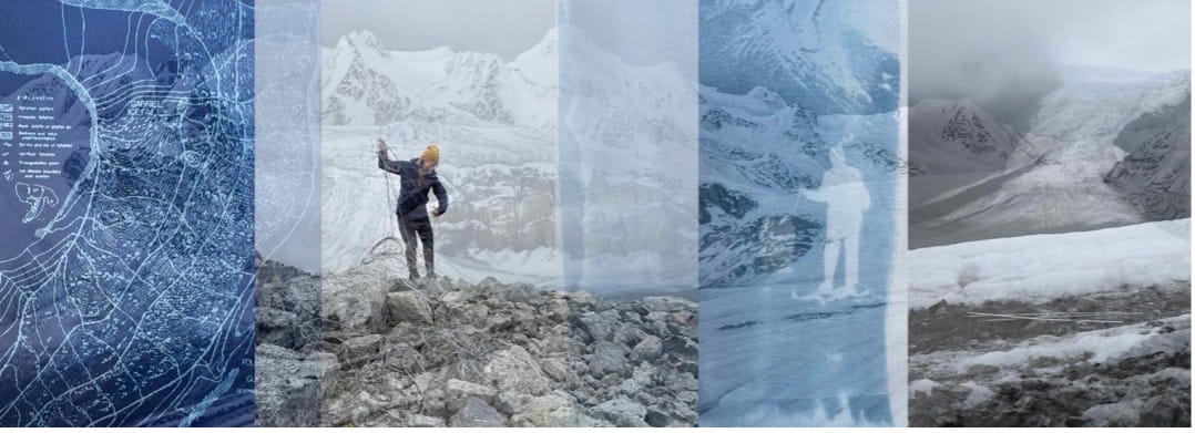
Layered images show how an anarchive can respond and tell many stories of C’ulc’ena’ Łuu’. Photo: Klara Maisch and Katie Ione Craney
The Arctic Institute Cryosphere Series 2026
- The Arctic Institute’s 2026 Connecting the Cryosphere Series: An Introduction
- A Map of the Arctic Ocean
- A Skier Goes for a Glacier Walk
- What Rights Cannot Hold: Sea Ice and the Exhaustion of Legal Imagination
- Collective Memory of C’ulc’ena’ Łuu’ / Gulkana Glacier
“Ice geographies are full of human history and politics, power relations, inequity, and state power.”1)
C’ulc’ena’ Łuu’ / Gulkana Glacier is a place of connection within Interior Alaska. Situated in Ahtna Athabascan homelands, C’ulc’ena’ Łuu’ is a continuum of cultural and geophysical processes. The dominant cultural, environmental, and political forces that have shaped Alaska in the last 125 years overlap on or are adjacent to the glacier.
As artists living in Alaska, we have been in conversation with glaciers as visitors, artists, and in our roles as educators and interdisciplinary researchers. We visited C’ulc’ena’ Łuu’ together for the first time last summer with an open-ended idea to collaborate and share stories of this place from many perspectives. With generous support from the Ursa Major Fund,2) we are in the early stages of creating Gulkana,3) an online anarchive featuring historical materials, community-centered stories, and artwork related to the glacier. Anarchiving is a process of gathering and sharing perspectives through a variety of mediums and firsthand experiences. Hosting the anarchive as a public website is a holistic approach towards sharing through materials and stories that may otherwise be kept private, siloed, or stored away.
C’ulc’ena’ Łuu’ is shaped by and adjacent to many complex geophysical and anthropogenic histories. This article provides an overview of overlapping histories and ongoing entanglements of land rights, resource extraction, militarization, climate change, and scientific study, and how these histories have brought us to this present moment with the glacier. To build an anarchive, and to situate ourselves and our artmaking with the glacier, we found it necessary to compile these stories into one narrative. Through this writing, and the development of an anarchive, we hope to create a space where meanings and questions can continually change and emerge. We approach this work as collaborators with C’ulc’ena’ Łuu’ to center firsthand knowledge, collective analysis, archival research, and sharing through a variety of mediums. Our approach is informed by many who know glaciers as living, active beings who communicate, listen, and respond.4) Centering C’ulc’ena’ Łuu’ in this article challenges colonial narratives to reveal more inclusive ways of listening, thinking, and being in relation with the glacier.
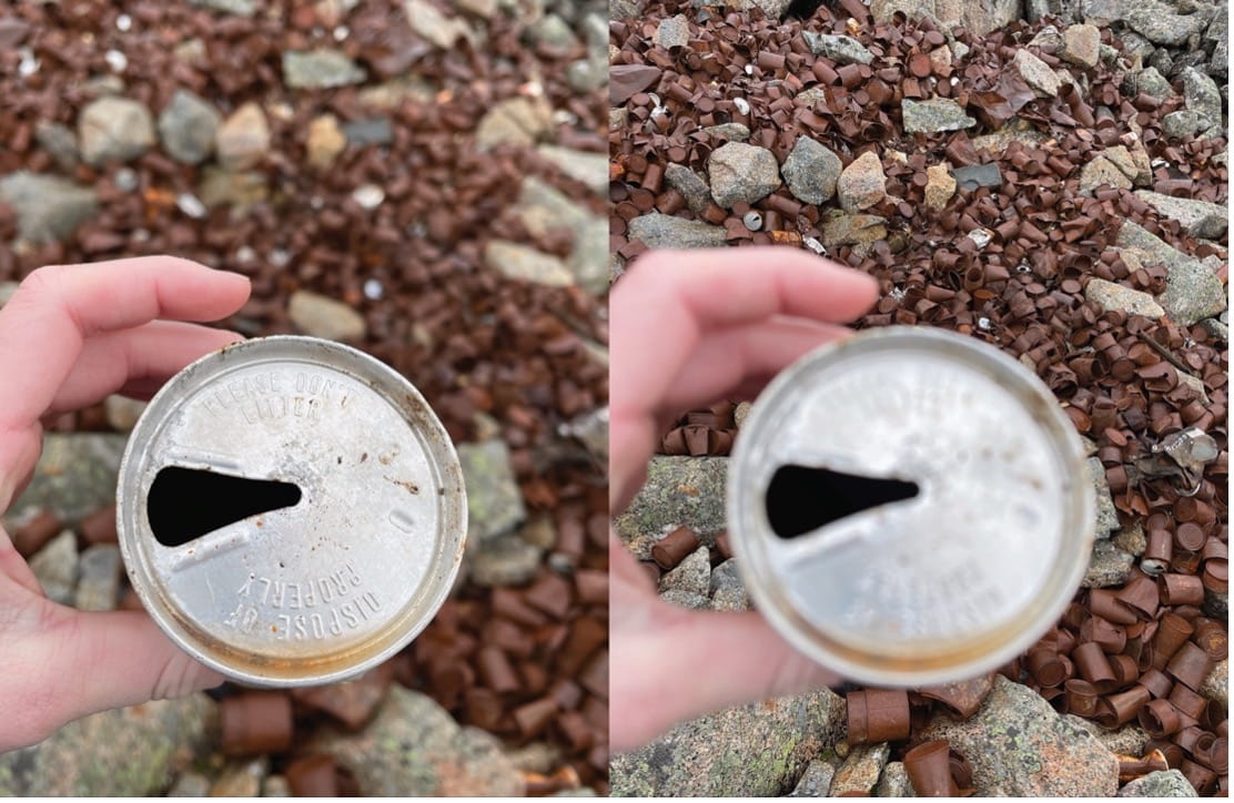
During our first visit with the glacier together, we photographed and spent time with materials left by the military on a moraine once covered by ice. We hiked over loose rock and followed long pieces of abandoned communication wire until we arrived at a place where thousands of metal food containers, packaging, and plastic utensils were left behind over decades of military training exercises.5) Most of the discarded materials are associated with military rations in the form of metal cans and MRE’s (Meal, Ready-to-Eat), but there are also leather boots, scraps of rope and canvas among other unidentified pieces of plastic, glass, and metal that are partially buried under rocks or in large piles on the moraine.
These materials are physical reminders of what the glacier has experienced and lived with over time. We are in the process of responding to these materials and histories to more expansively learn from and communicate with C’ulc’ena’ Łuu’, each other, and the many communities who visit and have connections with the glacier.
Situating the glacier
The story of C’ulc’ena’ Łuu’ is complex and evolving. The glacier and the surrounding area have become widely identified as a touchstone place for people who live in Interior Alaska. C’ulc’ena’ Łuu’ lives in Dghelaay, the mountains of the Eastern Alaska Range, along the northern stretch of upper Ahtna homelands,6) home of Ahtna Athabascans whose lands extend from Yidateni Na’, present-day Cantwell, along the southern edge of the Eastern Alaska Range to ‘Atna’ Nene’, the Copper River Basin, which runs between and is also fed by glaciers in the Chugach and Wrangell Mountains.7) The circular lived-in and lived-with territory of Ahtna lands is multidimensional and formed by glacial ice.8) The nearby Dzeł Ghatgge ‘Eni, ‘Pass between the Mountains,’ is a place of connection for Ahtna and Upper Tanana Athabascan for trade and seasonal rounds.9)
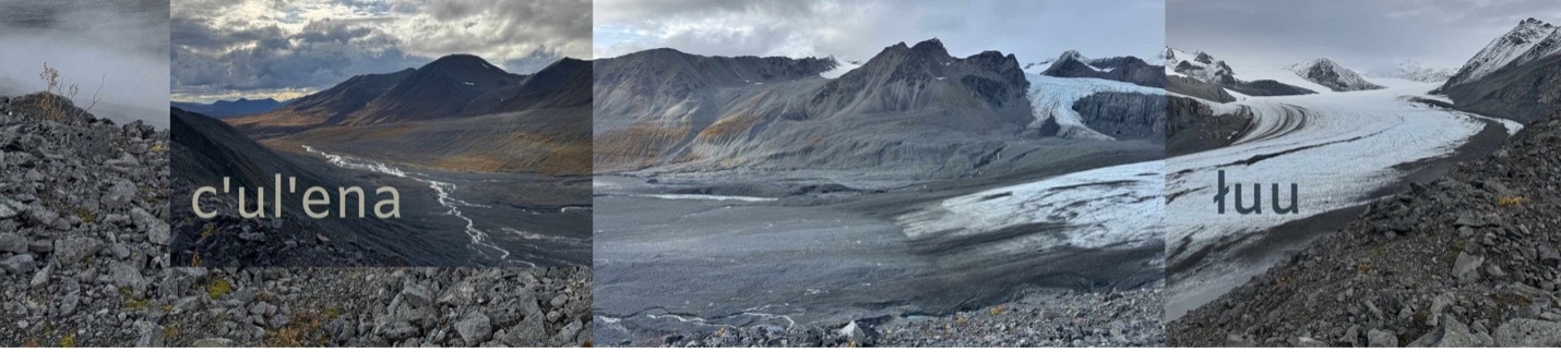
Ahtna travelled alongside the river and glacier of the same name, now known as Gulkana.10) In Ahtna, C’ulc’ena / Gulkana has been translated to ‘cutting stream,’ ‘tearing river,’ and ‘eroded river.’11) There are various recorded spellings of C’ulc’ena, reflecting colonial and “cartographic dispossession” strategies that actively erase oral Alaska Native place names.12) Beginning with Russian exploration (1780s to 1848), increased exploration and occupation of ‘Atna’ Nene’ / the Copper River Basin by fur traders, prospectors, and military personnel increasingly colonized through surveys and maps mixed with Ahtna and outsider place names.13) Gulkana was likely transcribed as how Euro-American documenters heard the original pronunciation of the Ahtna name. Record of the name Gulkana is included in the 1906 Geographic Dictionary of Alaska published by the United States Geological Survey as:
Gulkana; river and lake near its source, tributary to Copper river from the northwest, between Tazlina and Gakona rivers. Native name, adopted by the whites and reported by Mendenhall, 1902.14)
There is no known recorded Ahtna name specific to the glacier. In the Ahtna Athabaskan Dictionary, łuu translates to glacier, with a comment that “a glacier is usually named by the stream that flows from it.”15) Only recently have researchers and publications referred to Gulkana Glacier in Ahtna as C’ulc’ena’ Łuu’, “cutting stream glacier.”16) Gulkana Glacier, as written on present-day maps, was first recorded on a fieldsheet in 1910 by C. E. Giffin, a topographic engineer for the United States Geological Survey (USGS).17) From 1909 to 1917, Giffin traveled extensively throughout Alaska to map minerals and resources.18) It is unclear where he first heard the name Gulkana, or why he decided to label the glacier as such during his survey.
Access
The dominant cultural, social, and political forces that have shaped Alaska in the last 125 years are laid bare at the C’ulc’ena’ Łuu’. Following the 1867 U.S. purchase of Russia’s interests in Alaska, Ahtna lands, along with all present-day Alaska lands,19) became property of the United States, managed as a “military district,” where all lands effectively became “White man’s country” as stated by U.S. Senator William P. Dillingham.20) These inhabited lands became located, monetized, renamed, and essentially open for business to capitalist enterprise.
Access to ‘Atna’ Nene’ / the Copper River Basin steadily increased when gold claims along the Yukon River waned following the 1898 Klondike Gold Rush. Seekers pivoted and poured into Interior Alaska near present-day Fairbanks following a 1902 strike.21) One route into the interior was through an Ahtna trade and hunting trail that passed below C’ulc’ena’ Łuu’. Ahtna travelled extensive trail systems, including one through Dzeł Ghatgge / Isabel Pass, which eventually became part of the Richardson Highway, a travel artery connecting coastal Valdez to interior Fairbanks.22) The Valdez-Fairbanks trail became an important route leading to the establishment of the Alaska Road Commission (ARC), led by General Wilds P. Richardson, as appointed by President Theodore Roosevelt.23) By 1919, ARC designated the route a road, though it was not paved until 1957, two years before statehood and eleven years before Alaska’s oil boom.
All of this activity accelerated the influx of newcomers to Ahtna lands, which devastated local food supplies and divided lands into private and commercial properties for mining, hunting, fishing, homesteading, and as outposts and roadhouses along the route.24) As lands became increasingly parceled and surveyed, there were no treaties between Alaska Native tribes and the U.S. government. Due, in part, to the urgency to access and transport oil, the 1971Alaska Native Claims Settlement Act (ANSCA) attempted to remedy Alaska Native land rights. Through this process, Ahtna were left with about seven percent of their original homelands.25) Simeone and co-authors write that “Any preexisting Native institutions and forms of collective organization were ignored in the legislation.”26) ANCSA parceled lands into 12 regional, capitalistic corporations and 253 village corporations, leaving unresolved concerns regarding sovereignty, self-determination, and tribal governance that remain to this day.27)
The Trans-Alaska Pipeline System28) designed to transport crude oil 800 miles from Prudhoe Bay to a shipping terminal in Valdez, parallels nearly the entire length of the Richardson Highway. During construction, a camp was erected in the drainage valley of C’ulc’ena’ Łuu’ and housed up to 1,200 workers.29) Dismantled by 1980, the remaining gravel roads are unmaintained and continue to be used as the main entry point to access the glacier. A monument honoring Richardson now sits at a highway overlook of the C’ulc’ena’ Łuu’ valley.
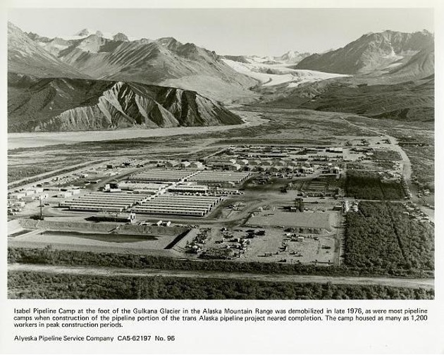
C’ulc’ena’ Łuu’ and the surrounding area are now federal and state lands. The Alaska Department of Natural Resources manages the glacier, glacier valley, and vast majority of the surrounding lands, and the federal Bureau of Land Management manages most of the lands directly around Dzeł Ghatgge / Isabel Pass.30) Records indicate that the glacier has experienced active mineral exploration as recently as 2022, echoing the geopolitical pressures on critical mineral exploration, disaster capitalism, and increased militarization across the Circumpolar North.31)
Warfare
Arctic warfare training in Alaska is heating up as geopolitical posturing and Arctic security measures increase. The U.S. Army began sending individuals to Alaska for Arctic and sub-Arctic training at Big Delta (later named Fort Greely) in 1948, under a program called The Arctic Indoctrination School.32) In 1957, the U.S. Army transferred full responsibility for the mission of enhancing mountain and cold region war-fighting capabilities and operations to the school, renaming it the U.S. Army Northern Warfare Training Center (NWTC) in 1963.33) NWTC is now headquartered at Fort Wainwright in Fairbanks, Alaska, with designated training grounds along the Richardson Highway, including the 3,807-acre Black Rapids Training Site, located approximately 30 miles north of C’ulc’ena’ Łuu’.34)
Training has occurred on and around the glacier for many years, as evident in numerous deposits of discarded materials. Although it is unknown when training first began on the glacier, a 1972 Department of Defense film release describes a week-long “Adventure Training” program on the glacier where a platoon engaged in a field march and training exercise.35)
The glacier continues to be a designated U.S. Army training site, where “glacial travel, ice climbing, rescue techniques, and glacial warfare” training occurs.36) Operations on and around the glacier are currently seeing an uptick as the Department of the Army is emphasizing Arctic strategy in response to growing national security concerns, increased political tensions over newly accessible economic resources and waterways, and geopolitical posturing to deter threats in the region.37) Between November 2022 and March 2023, student throughput at NWTC increased by 38 percent, the largest enrollment the school had experienced.38)
Glaciology
Extensive glaciological studies of C’ulc’ena’ Łuu’ began in 1960 with the University of Alaska Gulkana Glacier Project, which measured ablation and surface motion of the glacier with U.S. Army helicopter support.39) One of the field camps was located on the central moraine of the glacier, just below a rock outcropping surrounded by the Gabriel Icefall. Initial scientific studies attempted to quantify the materiality of the glacier and establish baselines for future projects.
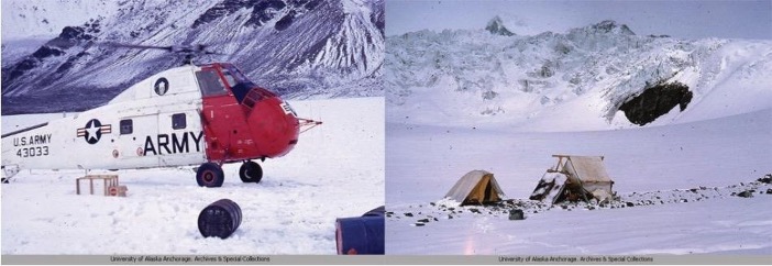
In 1966, the USGS built on earlier studies and began collecting mass balance, meteorological, and hydrological data as part of a long-term monitoring initiative to study five benchmark glaciers40) in North America, including C’ulc’ena’ Łuu’ and the Wolverine Glacier in Alaska. Long-term (5+ years) scientific projects are rare, and the Benchmark Glacier Project is the only long-term glacier monitoring program funded by a U.S. science agency. Funding for climate- related science and “non-defense-related research and development” is increasingly threatened by shifts in political power.41)
Creative Connections
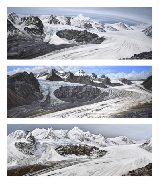
Klara has visited the glacier since childhood. In 2020, she began a repeat painting series from one perspective, hiking to the same place every September to paint on location over three days. Although the series started as a personal practice to visualize change over time, it quickly evolved into a research-intensive project informed by archival records and building relationships with people who are also connected with the glacier. This intimate and ongoing series is in its seventh year and is a continued attempt to reconsider how the glacier is studied and visualized.
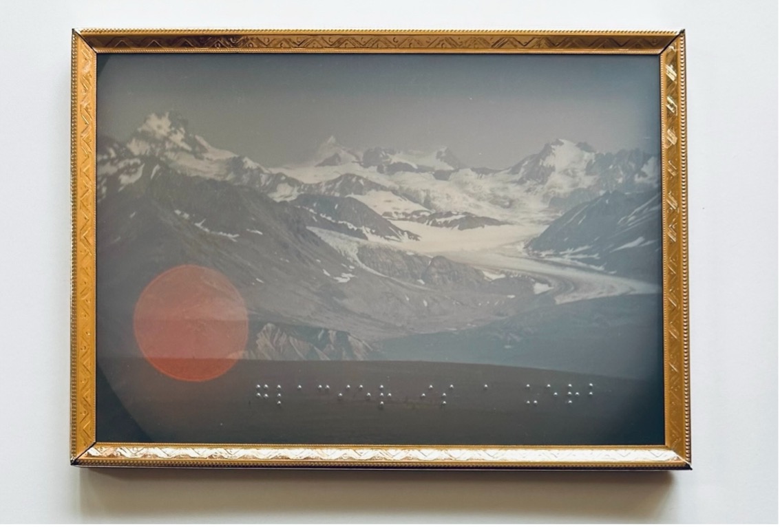
For most of her adult life, Katie has been in conversation with glaciers. She sees glaciers as verbs—as animate living, breathing, communicating beings. In her artmaking, she often combines imagery with scrap materials and words written in Braille to think through entangled relationships with accessibility and multiple ways of knowing. Learning to write in Braille is a communication attempt with her Great-Grandmother, who was blind. In glacier is a verb, C’ulc’ena’ Łuu’ is viewed through binoculars with a letter-for-letter Braille transcription of the title in the foreground.
Futures
How do we listen for different stories of the glacier? Will C’ulc’ena’ Łuu’ continue to see an increase in mining and military training exercises? How will access to the area change? How can we creatively converse with and care for the glacier? What questions and knowledge are held within our communities, both glacial and human? Creating a collective memory of the glacier as an anarchive provides space to think through these complex questions.
Our goal for this project is to explore human and more-than-human connections with C’ulc’ena’ Łuu’. To guide the next steps of our research, we are interviewing community members who have connections with the glacier and are inviting public contributions. The anarchive is intended to become an easily accessible hub for anyone who feels a connection with the glacier to share their experiences and connect their individual stories within wider historical and future-oriented contexts. As a combined memory of place, the anarchive is a starting place for how we can continue to expansively know and collectively care for C’ulc’ena’ Łuu’.
Katie Ione Craney and Klara Maisch are artists living in Fairbanks, Alaska. They thank C’ulc’ena’ Łuu’ for the many connections that continue to bring this project together.
References