Ships in the Arctic Need to Plan to Survive Until Help Arrives
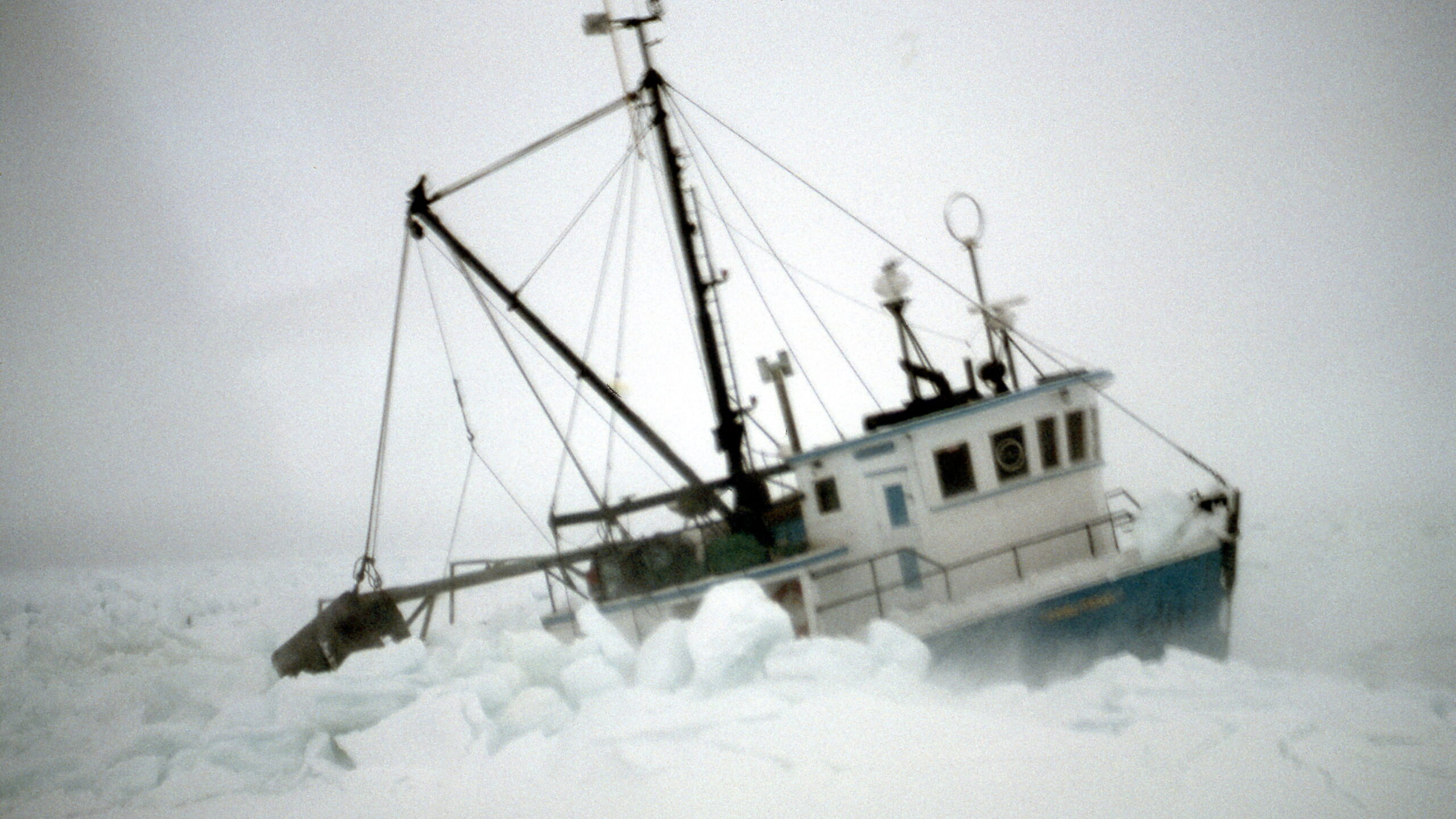
This fishing vessel got caught in drift ice and the ice broke the rudder, sprung hull planks, broke off the gallows and put over ten tonnes of ice on deck. The ship listed badly and water was coming in through the sprung planks. The Canadian Coast Guard inspected the vessel at sea, put SAR pumps on board and successfully got the fishing vessel back to port. Photo: Jack Gallagher
The Arctic Institute Polar Disaster Series 2026
- The Arctic Institute’s 2026 Polar Disaster Risk Reduction and Response Series: An Introduction
- Crisis Management in Arctic Communities: Principles of Crisis Response
- Disaster Risk Reduction and Response: Greenland
- Risk Analysis of Infrastructure Vulnerability and Sustainable Resource Exploitation in the Arctic
- Ships in the Arctic Need to Plan to Survive Until Help Arrives
- From Pandemic to Permafrost: Legal Pathways for One Health Preparedness in Arctic Communities
- Icebergs and Navigation Safety in Antarctica: Possible Impact of new Sea-Ice Regime in the Southern Ocean and South Atlantic Ocean
Every ship, in every part of the world, has two major responsibilities if they have an emergency and expect to be rescued. The first responsibility is to alert the Search and Rescue (SAR) system that they are in distress. The second responsibility is to be prepared to survive until help arrives. In polar regions, both responsibilities require special consideration.
The first responsibility seems intuitive but in an Arctic context, where in the not-too-distant past communications were very difficult, this was a particular challenge. Shoreside infrastructure for coastal radio stations was sparse and the meteorological conditions were often ideal for creating sub-refraction and super-refraction of radio waves, which means that the signals did not propagate in a normal and expected fashion. In addition to these difficulties, the only approved satellite system for SAR communications theoretically provided coverage up to 82 degrees latitude, but was often unreliable at latitudes north of 70 degrees. With the addition of the Iridium constellation to the SAR communications network, the past difficulties have been largely overcome for those ships fitting the Iridium solution. Iridium satellites are low earth orbit satellites that are in polar orbits. As every satellite crosses the pole during its orbit there is a high level of coverage in the polar regions.1)
To ensure that a ship’s complement is prepared to survive until help arrives, they have a suite of equipment and training. Ships are equipped with firefighting equipment, they carry dewatering pumps, timber for shoring up bulkheads and ancillary tools as damage control supplies and should it become necessary to abandon ship, they have lifeboats, life rafts, life jackets and survival suits. Ship personnel take courses on marine emergency duties as basic preparation, and they conduct drills on board to keep up their skills and to develop specific shipboard strategies and procedures.
The International Code for Ships Operating in Polar Waters2) came into force on 1 January 2017, to improve the safety for ship operations in polar waters, covering both the Arctic and the Antarctic. When planning for polar operations, a ship must complete a risk assessment and develop a Polar Water Operations Manual (PWOM). Part of the risk assessment and operations manual deals with shipboard emergencies.
To have a starting point for the assessment and associated manual, a ship must determine how long they should plan to survive until help arrives. This time is called the Maximum Expected Time to Rescue (METR). Once a shipowner has determined what the METR is, it is put on the Polar Ship Certificate which is signed off by the ship’s maritime administration or a classification society on their behalf.
Determining the METR for ocean rescue is not like land-based emergency response. In many cities one can easily look up emergency service standards. In Halifax, Canada, if one calls with a fire emergency, the standard states that fourteen firefighters and associated equipment will arrive at the incident location in no more than eleven minutes. In Canada, marine SAR is provided by the aircraft of the Royal Canadian Air Force (RCAF) and the ships of the Canadian Coast Guard (CCG). Both organizations have a service standard that states how long it will take to get their capability underway but nothing about how long it will take to arrive.
Given the high variability of sea states, weather and ice conditions it can be problematic to determine how long arrival will take in the vast SAR Regions under Canadian jurisdiction.3) Canadian SAR Regions extend 600 nautical miles into the Pacific Ocean, 900 nautical miles into the Atlantic Ocean and up to the North Pole. Determining arrival times is complex and must recognize that many locations are out of range of the SAR helicopters and the locations of CCG ships and vessels of opportunity are highly variable. In the Arctic, additional complications are variable ice and uncertain bathymetry. Determining the fastest, safest route takes some time and expertise.
The project
A project was undertaken to model SAR response services in the Canadian Arctic to develop a tool that companies and regulators can use as a reference when determining the METR. The project team was multi-disciplinary and included experts from Dalhousie University, Memorial University and St. Francis Xavier University. The project was predominately funded by the Canadian National Search and Rescue Secretariat with additional funding from Canadian Coast Guard, Dalhousie University and the Ocean Frontier Institute’s Future Ocean and Coastal Infrastructures (FOCI) project.
The project team is indebted to the many individuals, companies and organizations that gave so freely of their time and expertise as the research team worked to identify the factors, processes and risks of various aspects of SAR response operations.
The project team started with defining what “to be rescued” meant in the context of METR. The International Convention on Maritime Search and Rescue4) defines rescue as:
“An operation to retrieve persons in distress, provide for their initial medical or other needs, and deliver them to a place of safety.”
Using the international definition would have been problematic as there are very few “places of safety” in the Arctic, particularly if medical care is needed for any number of casualties. Due to this factor, casualties rescued in the Canadian Arctic are often in the care and custody of the SAR system until they are landed somewhere in southern Canada with medical facilities and where housing the survivors is not an undue strain on the sanitary facilities or food supplies as might be the case in the north.
For the METR study it was assumed that the whole ship complement was at risk and needed to be evacuated, and that the METR would be from the time of notification of the SAR system until the last person was removed to a responding SAR helicopter or ship. At this time, the survivors are no longer relying on the ship’s resources for survival. From the SAR system perspective, the rescue may be far from over but for the purposes of calculating an expected time to rescue, this demarcation was necessary.
The study made three broad assumptions that were tested during the project:
- Where the incident happened (location) mattered.
- The time of year (temporal divisions) mattered.
- The number of persons on board (magnitude) mattered.
The Canadian Arctic Waters Pollution Prevention Act5) divides the Arctic into sixteen Shipping Safety Control Zones. The zones were used as a starting point for geographically subdividing the area as they are well known by those who work in the Arctic and could be modified if compelling data arose during the study. Although the zones were considered a starting point, to test whether they are suitable subdivisions, the Arctic waters were divided into 361 grids of 100 kilometers by 100 kilometers each. Responses to incident scenarios were modelled to the center of every grid square. The times of response were compared to other grids within each zone to determine if the outcomes were sufficiently close to yield a uniform METR in each zone.
Sailing to the Arctic in September, when conditions are most benign and there are a higher number of vessels that can provide ample rescue services, is very different than attempting a voyage in February in darkness, harsh ice conditions, and when there are few available rescue resources. Several options were considered for temporal division including dividing the year into two, three and four subdivisions.
It was determined during expert interviews that the time involved to rescue a small complement of twelve persons would be less than the time required for the rescue of several hundred persons. During the project, information was gathered as to what factor or factors would primarily affect this component. It was decided that rescue from survival craft is the most time-consuming scenario so in every case all personnel had evacuated from the ship into lifeboats and/or life rafts.
The study held a series of workshops with staff from the Joint Rescue Coordination Centers at Trenton, Ontario and Halifax, Nova Scotia that are responsible for the Canadian Arctic, RCAF rescue pilots and SAR technicians, and marine responders including those from CCG ships and commercial vessels of opportunity. The workshops also provided key contacts that allowed researchers to dig deeper into areas where additional information was needed for the modelling. Project members also gathered information through their participation in the Nunavut6) and Nunavik.7) Search and Rescue Roundtables – collaborative platforms in which Inuit community responders and their government partners meet to strengthen the SAR system in the Arctic.
The study looked at two years’ of ship AIS (Automatic Identification System) data to determine where ships are at various times of year and the routes that they generally travelled. The ships were catalogued by type and ice class so that transit times and capability could be assessed.
Historic ice conditions were used with ship routing and speeds derived from a model that incorporates data including ice information and the ships’ ice class.8) The Polar Operational Limit Assessment Risk Indexing System (POLARIS)9) was utilized to determine an ice numeral and therefore what ice a particular ship can and cannot enter. Speeds were also set that reflect the reality of transits in ice-covered waters that were related to the vessel ice class and the type and amount of ice. The study included “vessels of opportunity” (VOO) as they are a normal resource for response to SAR incidents and if they were excluded the results may be skewed due to the small number of CCG vessels and the vastness of the area. It was necessary to make some assumptions as to the capability of VOO whereas in reality they vary widely from small tugs to tankers and cargo ships. The resulting model calculated the transit times for all CCG vessel and VOO to every potential incident scene.
Rules were developed that set parameters for response.
- Every VOO (other than cruise ships) can rescue and accommodate up to 50 persons.
- Every CCG ship and every cruise vessel VOO can accommodate all persons at risk.
- Every response to a cruise vessel incident must be by another cruise vessel VOO or a CCG vessel.
- Other ships in distress that have a complement of more than 50 persons are treated as cruise vessels.
SAR helicopters are all based in southern Canada and have long transit times to all Arctic locations. To southerly Arctic locations there is need for a minimum of one fueling stop. As the distances increase, in addition to fuel, crew changes must be arranged. This requires fixed wing aircraft to ferry crews ahead of the helicopter so they can swap out at the second or third refueling stop. Airports with the availability of pressurized fuelling are preferred to keep refuelling time under thirty minutes. At remote fuel caches, fuelling from barrels can take up to three hours.
SAR fixed wing aircraft are huge assets as they can drop equipment, supplies and medical support but they do not have the capability to “rescue” the persons in distress. For this reason, the response times of the fixed wing aircraft were not considered in the modelling.
The findings
SAR Helicopters
The SAR helicopters are very capable assets but have limited range and survivor capacity. Modelling of very remote sections of the Arctic showed areas where seven refuelling stops were required during the transit from the base to the incident location.10)
Each time the helicopter is shut down for refueling there is a chance that some piece of mission-critical equipment will not be serviceable on start up. This has not been quantified in detail, but the general outcome is that more fuelling stops translates into increased likelihood of the aircraft becoming unserviceable.
From a logistical standpoint, as the locations become more remote, the number of suitable locations to exchange crews also diminishes.
During the workshops, the helicopter personnel indicated that a helicopter is not the ideal tool for mass rescue. Their ideal operation is hoisting one or two persons and transferring them to a medical facility ashore. When operations include hoisting more than six persons, the complexity of the operation increases substantially. The experts were of the opinion that any rescue of more than 20 persons should be a maritime response with a helicopter assist. They recounted instances where they have completed very challenging operations with higher numbers of persons hoisted and multiple trips to hoist high numbers of persons but in their professional opinion it was not prudent to use the outlier incidents for planning purposes.
The study did not want to err too far on the side of caution so set the cutoff for a rescue completed entirely by helicopter at 24 persons. This would normally require a minimum of two loads by the Cormorant helicopter depending on how far the incident is from the nearest fuel stop.
The modelling considered historical weather at all enroute stops and operations were slowed down or significantly delayed if the weather was unsuitable. Weather suitability can be related to wind speed, wind gusts, visibility or icing conditions.
Marine Rescue
Marine rescues were assessed for all cases based on the rules identified. In the prime navigation season, there are two major factors that underlie short rescue times: light ice conditions and higher numbers of vessels of opportunity.
During consultations, it was determined that end-use clients of modelling results preferred to have the results available in temporal segments as short as two weeks. This required running scenarios for every two-week period and it became quite illustrative of how time of year has a significant impact on the expected METR.
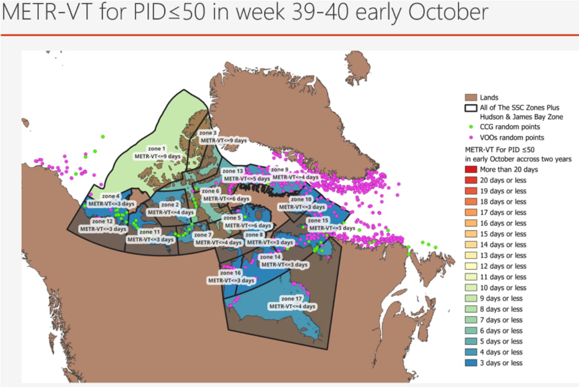
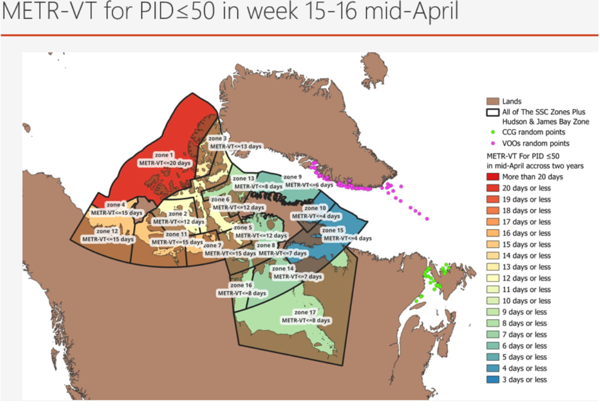
Generally during the prime navigation season, using five days for the METR is reasonable for the areas where shipping is mostly found. In the high, western Arctic, west of Banks Island and above (zone 1 in Figures 1 & 2), the METR never did drop to the five-day threshold but did drop down to eight days for the least challenging four-week period.
The five days METR value quickly becomes insufficient prior to, or after, the prime season except for the lower Arctic, Hudson Strait, and Hudson Bay areas where it remains under five days for an extra few weeks.
During the winter season, using an METR of five days is not reasonable at all. Some areas, although showing an METR of nineteen days, have little hope of having a marine resource on scene as there will be no place to get the fuel needed to transit in the prevailing ice conditions. Figures 1 and 2 show the great disparity in response vessel transit times during two distinct periods based on 2018 and 2019 data.11)
Conclusion
The study conducted indicates that any operations in very remote parts of the Canadian Arctic and any operations outside of the prime summer navigation season require a METR of more than five days. The study was based on a two-year data set, 2018 and 2019, and it would be beneficial to input additional data to produce more robust results. The study final report can be downloaded here: https://www.maritimeriskandsafety.ca/projects/metr/.
Jack Gallagher is the owner and principal consultant of Hammurabi Consulting (www.hammurabi.ca) and the other authors are affiliated with Dalhousie University, St. Francis Xavier University, and the Marine Institute of The Memorial University of Newfoundland.
References